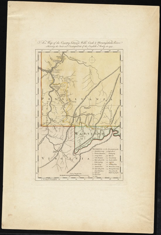
A map of the country between Will's Creek & Monongahela River shewing the rout and encampments of the English army in 1755
This map is also available in American Revolutionary Geographies Online (ARGO), a collections portal especially built for material relating to the American Revolutionary War Era. Visit ARGO to learn more about this item and explore the historical geography of North America in the late eighteenth century.
Item Information
- Title:
- A map of the country between Will's Creek & Monongahela River shewing the rout and encampments of the English army in 1755
- Creator:
- Orme, Robert, -1781
- Contributor:
- Jefferys, Thomas, -1771
- Contributor:
- Sayer, Robert, 1725-1794
- Date:
-
[1768]
- Format:
-
Maps/Atlases
- Location:
- George Washington's Mount Vernon
- Collection (local):
-
Richard H. Brown Revolutionary War Map Collection at Mount Vernon
- Subjects:
-
Military camps--Maps--Early works to 1800
Braddock's Campaign, 1755--Maps--Early works to 1800
United States--History--French and Indian War, 1754-1763--Maps--Early works to 1800
Maryland--Maps--Early works to 1800
Pennsylvania--Maps--Early works to 1800
Virginia--Maps--Early works to 1800
- Places:
-
Maryland
Pennsylvania
Virginia
- Extent:
- 1 map : hand col. ; 29 x 19 cm.
- Terms of Use:
-
No known copyright restrictions.
This work is licensed for use under a Creative Commons Attribution Non-Commercial Share Alike License (CC BY-NC-SA).

- Publisher:
-
London :
Printed for Robert Sayer, ... and Thomas Jefferys
- Scale:
-
Scale [ca. 1:735,000]
- Language:
-
English
- Catalog Record:
-
MVLA record
- Notes:
-
Shows Braddock's route and encampments in his campaign on Fort Duquesne.
Prime meridian: Philadelphia.
Relief shown pictorially.
Includes references.
Appears in Jefferys' General topography of North America and the West Indies. London: Printed for Robert Sayer, ... and Thomas Jefferys, 1768.
- Notes (date):
-
This date is inferred.
- Notes (citation):
-
Phillips. List of maps of America, p. 269
Phillips, 1196
- Identifier:
-
06_01_011882
- Barcode:
-
30000003254677


