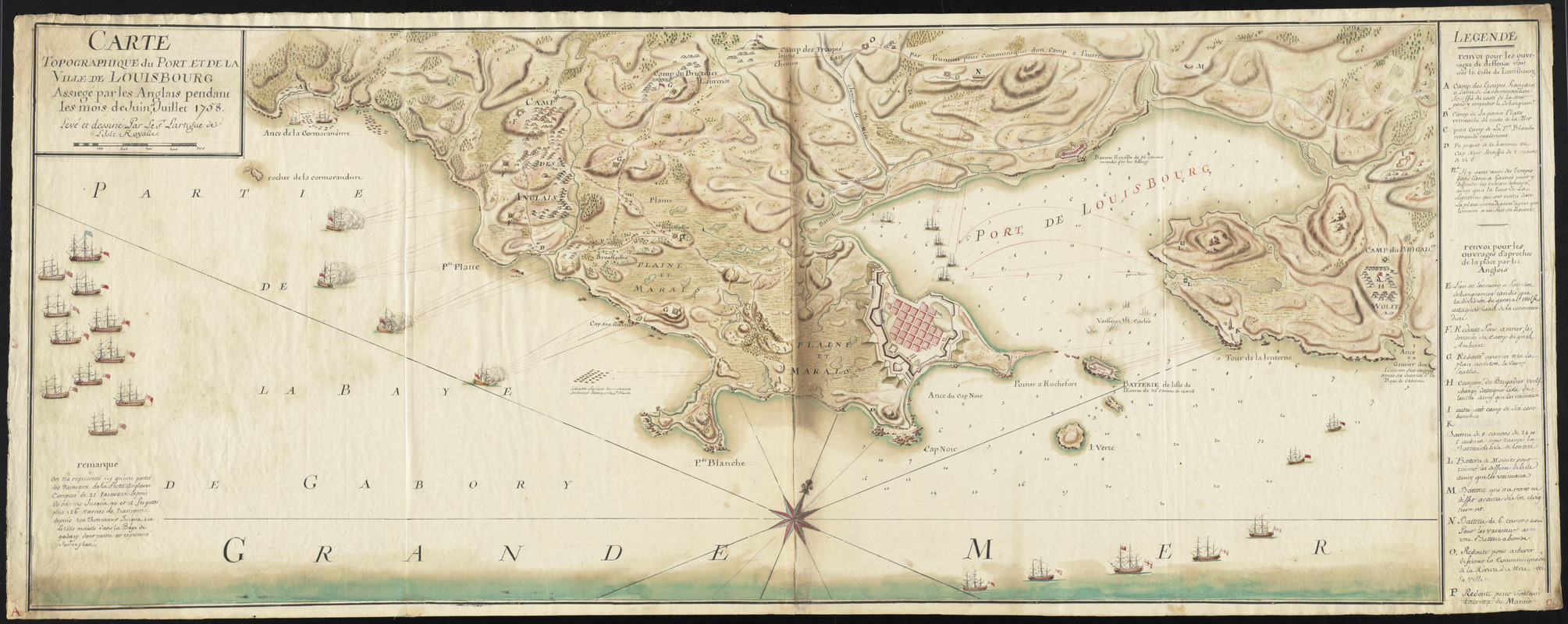
Carte topographique du port et de la ville de Louisbourg, assiegé par les Anglais pendant les mois de Juin, Juillet 1758
This map is also available in American Revolutionary Geographies Online (ARGO), a collections portal especially built for material relating to the American Revolutionary War Era. Visit ARGO to learn more about this item and explore the historical geography of North America in the late eighteenth century.
Item Information
- Title:
- Carte topographique du port et de la ville de Louisbourg, assiegé par les Anglais pendant les mois de Juin, Juillet 1758
- Description:
-
Colored manuscript map of the 1758 siege of Louisbourg showing ships, troop positions, camps and batteries. Includes references to points of interest, notes and description of the English fleet.
- Creator:
- Lartigue, Pierre-Jérome, 1729-1772
- Name on Item:
-
levé et dessiné par le Sr. Lartigue l'ainé de l'Isle Royalle.
- Date:
-
[1758]
- Format:
-
Maps/Atlases
Manuscripts
- Location:
- George Washington's Mount Vernon
- Collection (local):
-
Richard H. Brown Revolutionary War Map Collection at Mount Vernon
- Subjects:
-
Louisbourg (N.S.)--History--Siege, 1758--Maps--Early works to 1800
United States--History--French and Indian War, 1754-1763--Maps--Early works to 1800
- Places:
-
CanadaLouisbourg
- Extent:
- 1 manuscript map : hand col. ; 40 x 105 cm.
- Terms of Use:
-
No known copyright restrictions.
This work is licensed for use under a Creative Commons Attribution Non-Commercial Share Alike License (CC BY-NC-SA).

- Scale:
-
Scale [ca. 1:11,500]
- Language:
-
French
- Catalog Record:
-
MVLA record
- Notes:
-
Oriented with north towards the upper right.
Relief shown by gradient tints. Depths shown by soundings.
In French.
- Notes (date):
-
This date is inferred.
- Identifier:
-
06_01_011754