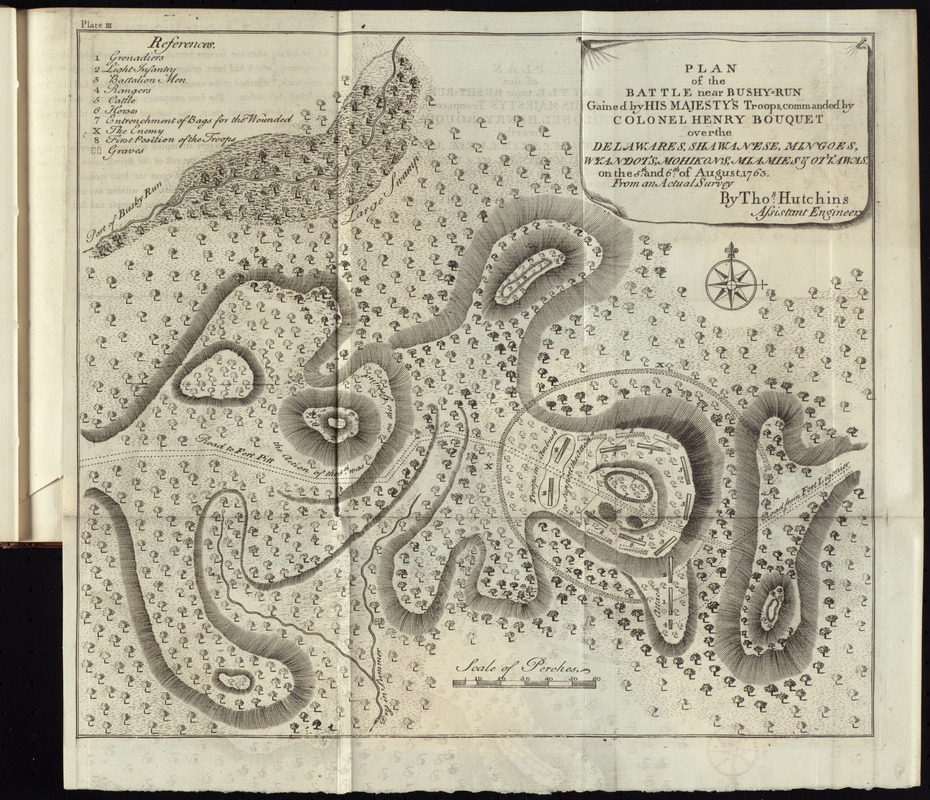
Plan of the battle near Bushy-Run gained by His Majesty's troops commanded by Colonel Henry Bouquet over the Delawares, Shawanese, Mingoes, Wyandots, Mohikons, Miamies & Ottawas, on the 5th and 6th of August, 1763, from an actual survey
This map is also available in American Revolutionary Geographies Online (ARGO), a collections portal especially built for material relating to the American Revolutionary War Era. Visit ARGO to learn more about this item and explore the historical geography of North America in the late eighteenth century.
Item Information
- Title:
- Plan of the battle near Bushy-Run gained by His Majesty's troops commanded by Colonel Henry Bouquet over the Delawares, Shawanese, Mingoes, Wyandots, Mohikons, Miamies & Ottawas, on the 5th and 6th of August, 1763, from an actual survey
- Creator:
- Hutchins, Thomas, 1730-1789
- Name on Item:
-
by Thos. Hutchins, assistant engineer.
- Date:
-
[1765]
- Format:
-
Maps/Atlases
- Location:
- George Washington's Mount Vernon
- Collection (local):
-
Richard H. Brown Revolutionary War Map Collection at Mount Vernon
- Subjects:
-
Bushy Run, Battle of, Pa., 1763--Maps--Early works to 1800
Pontiac's Conspiracy, 1763-1765--Maps--Early works to 1800
- Places:
-
Westmoreland (county)Bushy Run Battlefield (historic site)
- Extent:
- 1 map ; 29 x 33 cm.
- Terms of Use:
-
No known copyright restrictions.
This work is licensed for use under a Creative Commons Attribution Non-Commercial Share Alike License (CC BY-NC-SA).

- Publisher:
-
Philadelphia :
Printed and sold by William Bradford
- Scale:
-
Scale [ca. 1:5,250]
- Language:
-
English
- Catalog Record:
-
MVLA record
- Notes:
-
Relief shown by hachures.
Topographical map of battlefield showing positions of opposing forces.
Includes table of references identifying units.
In upper left: plate III.
In William Smith's An historical account of the expedition against the Ohio Indians, in the year 1764, under the command of Henry Bouquet, Esq. (Philadelphia : William Bradford, 1765).
- Notes (date):
-
This date is inferred.
- Identifier:
-
06_01_010193

![[A map of part of Pennsylvania & Maryland intended to shew, at one view, the several places proposed for opening a communication between the waters of the Delaware & Chesopeak Bays]](https://bpldcassets.blob.core.windows.net/derivatives/images/commonwealth:z603vt12v/image_thumbnail_300.jpg)


