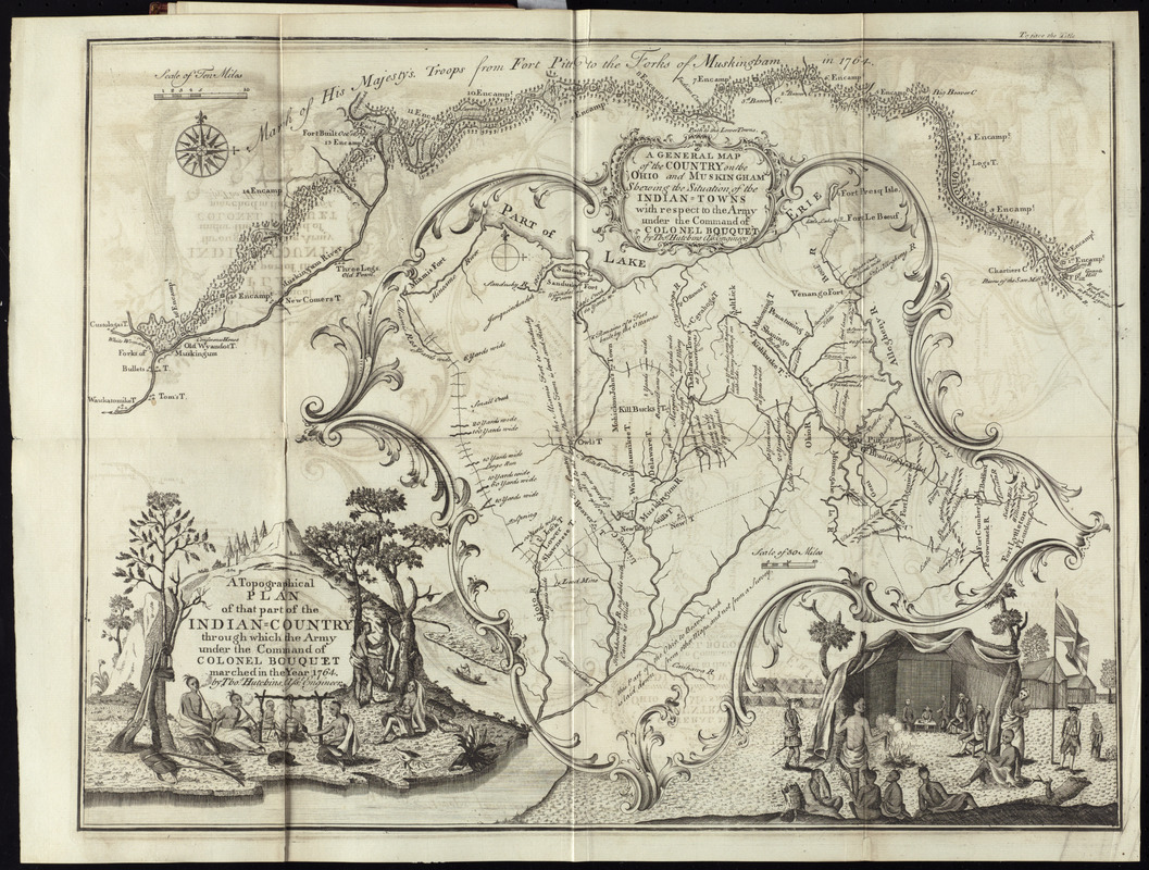
A topographical plan of that part of the Indian-country through which Colonel Bouquet marched in the year, 1764
This map is also available in American Revolutionary Geographies Online (ARGO), a collections portal especially built for material relating to the American Revolutionary War Era. Visit ARGO to learn more about this item and explore the historical geography of North America in the late eighteenth century.
Item Information
- Title:
- A topographical plan of that part of the Indian-country through which Colonel Bouquet marched in the year, 1764
- Title (alt.):
-
General map of the country on the Ohio and Muskingham shewing the situation of the Indian-towns with respect to the army under the command of Colonel Bouquet
- Description:
-
The rare map displayed here was the first detailed map illustrating the Ohio Valley based on actual survey, and was the earliest map of the Midwest published in America. The map served as the frontispiece for William Smith's "An historical account of the expedition against the Ohio indians, in the year 1764, under the command of Henry Bouquet, Esq." (Philadelphia : William Bradford, 1765). The first of two maps on this sheet, "A Topographical Plan ...", depicts Col. Henry Bouquet's march from Fort Pitt to the forks of the Muskingum River in October 1764. Hutchins served as assistant engineer on the expedition. The second map, "A General Map ...", shows all of western Pennsylvania and Ohio east of the Scioto River, and includes notes on the topography, Native American villages, forts, and Bouquet's route. There are two decorative cartouches in each corner of the map; one depicts Native American life, the other shows the the encampment at the Forks of Muskingun and the parlay with the Native Americans.
- Creator:
- Hutchins, Thomas, 1730-1789
- Name on Item:
-
by Thos. Hutchins
- Date:
-
[1765]
- Format:
-
Maps/Atlases
- Location:
- George Washington's Mount Vernon
- Collection (local):
-
Richard H. Brown Revolutionary War Map Collection at Mount Vernon
- Subjects:
-
Bouquet's Expedition, 1764--Maps--Early works to 1800
Indians of North America--Ohio--Maps--Early works to 1800
Pennsylvania--Maps--Early works to 1800
Ohio--Maps--Early works to 1800
- Places:
-
Pennsylvania
Ohio
- Extent:
- 2 maps on 1 sheet ; sheet 37 x 49 cm.
- Terms of Use:
-
No known copyright restrictions.
This work is licensed for use under a Creative Commons Attribution Non-Commercial Share Alike License (CC BY-NC-SA).

- Publisher:
-
Philadelphia :
Printed and sold by William Bradford
- Scale:
-
Scale [ca. 1:375,000]
Scale [ca. 1:1,950,000]
- Language:
-
English
- Catalog Record:
-
MVLA record
- Notes:
-
Shows eastern Ohio and western Pennsylvania.
Titles in decorative cartouches.
In William Smith's An historical account of the expedition against the Ohio Indians, in the year 1764, under the command of Henry Bouquet, Esq. (Philadelphia : William Bradford, 1765)..
- Notes (date):
-
This date is inferred.
- Notes (citation):
-
Brown, L. Early maps of the Ohio Valley, 45
- Identifier:
-
06_01_010192
- Barcode:
-
30000003237176


![[A map of part of Pennsylvania & Maryland intended to shew, at one view, the several places proposed for opening a communication between the waters of the Delaware & Chesopeak Bays]](https://bpldcassets.blob.core.windows.net/derivatives/images/commonwealth:z603vt12v/image_thumbnail_300.jpg)

