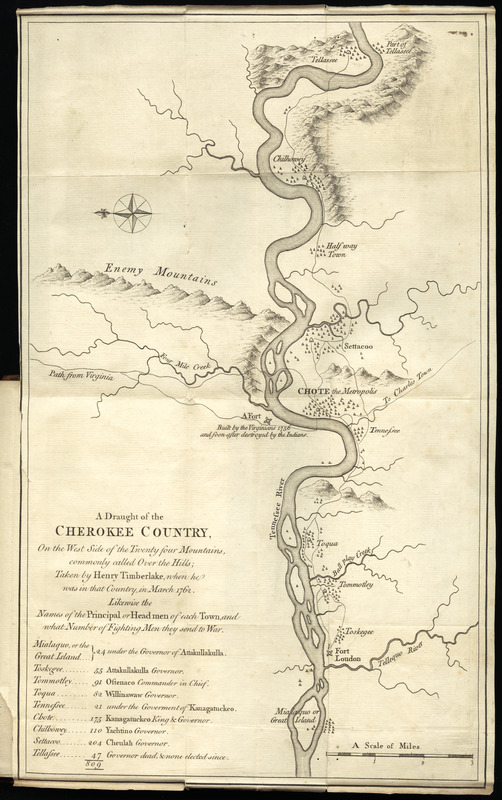
A draught of the Cherokee Country : on the west side of the Twenty Four Mountains, commonly called Over the Hills
This map is also available in American Revolutionary Geographies Online (ARGO), a collections portal especially built for material relating to the American Revolutionary War Era. Visit ARGO to learn more about this item and explore the historical geography of North America in the late eighteenth century.
Item Information
- Title:
- A draught of the Cherokee Country : on the west side of the Twenty Four Mountains, commonly called Over the Hills
- Creator:
- Timberlake, Henry, -1765
- Name on Item:
-
taken by Henry Timberlake, when he was in that country, in Mar. 1762
- Date:
-
1765
- Format:
-
Maps/Atlases
- Location:
- George Washington's Mount Vernon
- Collection (local):
-
Richard H. Brown Revolutionary War Map Collection at Mount Vernon
- Subjects:
-
Indians of North America--Little Tennessee River Valley (Ga.-Tenn.)--Maps--Early works to 1800
Cherokee Indians--Tennessee--Maps--Early works to 1800
Fort Loudoun State Historic Area (Tenn.)--Maps--Early works to 1800
- Places:
-
Little Tennessee River
- Extent:
- 1 map ; 38 x 23 cm.
- Terms of Use:
-
No known copyright restrictions.
This work is licensed for use under a Creative Commons Attribution Non-Commercial Share Alike License (CC BY-NC-SA).

- Publisher:
-
London :
Printed for the author ; and sold by J. Ridley ... W. Nicoll ... and C. Henderson
- Scale:
-
Scale [ca. 1:65,000]
- Language:
-
English
- Catalog Record:
-
MVLA record
- Notes:
-
Oriented wiith north to the left.
Relief shown pictorially.
Covers Fort Loudoun and part of the Little Tennessee River.
Includes a list of the "Names of the principal or headmen of each town, and what number of fighting men they send to war."
In the author's Memoirs of Lieut. Henry Timberlake..
- Notes (citation):
-
Cumming, W.P. Southeast in early maps, 349
- Identifier:
-
06_01_010187
- Barcode:
-
30000003236919

![[A map of part of Pennsylvania & Maryland intended to shew, at one view, the several places proposed for opening a communication between the waters of the Delaware & Chesopeak Bays]](https://bpldcassets.blob.core.windows.net/derivatives/images/commonwealth:z603vt12v/image_thumbnail_300.jpg)


