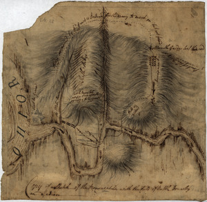
[Ein grund-riss von der Festung Duquessne wie sie ausgesehen hat, ehe sie die Frankosen zerstoren aben, und zum theil noch aussiehet]
![[Ein grund-riss von der Festung Duquessne wie sie ausgesehen hat, ehe sie die Frankosen zerstoren aben, und zum theil noch aussiehet]](https://bpldcassets.blob.core.windows.net/derivatives/images/commonwealth:z603vv49q/image_access_800.jpg)
This map is also available in American Revolutionary Geographies Online (ARGO), a collections portal especially built for material relating to the American Revolutionary War Era. Visit ARGO to learn more about this item and explore the historical geography of North America in the late eighteenth century.
Item Information
- Title:
- [Ein grund-riss von der Festung Duquessne wie sie ausgesehen hat, ehe sie die Frankosen zerstoren aben, und zum theil noch aussiehet]
- Date:
-
[1758?–1759?]
- Format:
-
Maps/Atlases
- Location:
- George Washington's Mount Vernon
- Collection (local):
-
Richard H. Brown Revolutionary War Map Collection at Mount Vernon
- Subjects:
-
Fort Duquesne (Pa.)--Maps--Early works to 1800
- Places:
-
Allegheny (county)Pittsburgh
- Extent:
- 1 map ; 20 x 23 cm., on leaf 35 x 22 cm.
- Terms of Use:
-
No known copyright restrictions.
This work is licensed for use under a Creative Commons Attribution Non-Commercial Share Alike License (CC BY-NC-SA).

- Publisher:
-
Germany? :
[s.n.]
- Scale:
-
Scale [ca. 1:800]
- Language:
-
German
- Catalog Record:
-
MVLA record
- Notes:
-
Plan of Fort Duquesne before its destruction in 1758.
Relief shown pictorially.
Includes references to points of interest.
Leaf includes [prayer?] verse in German in double columns, both sides.
At head of verse: Es ist ein lied zu handen gekommen, welches ein prediger in Darmstadt gemacht hat auf einen fast-[B]uss und [B]at-Tag, und beh gegenwartigen umstanden auch hier mit Russen tan gelesen werden.
- Identifier:
-
06_01_010190


![[A map of part of Pennsylvania & Maryland intended to shew, at one view, the several places proposed for opening a communication between the waters of the Delaware & Chesopeak Bays]](https://bpldcassets.blob.core.windows.net/derivatives/images/commonwealth:z603vt12v/image_thumbnail_300.jpg)
