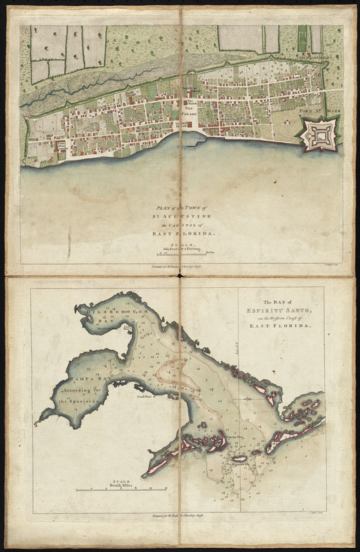
Plan of the town of St. Augustine, the capital of East Florida ; The bay of Espiritu Santo, on the western coast of East Florida
This map is also available in American Revolutionary Geographies Online (ARGO), a collections portal especially built for material relating to the American Revolutionary War Era. Visit ARGO to learn more about this item and explore the historical geography of North America in the late eighteenth century.
Item Information
- Title:
- Plan of the town of St. Augustine, the capital of East Florida ; The bay of Espiritu Santo, on the western coast of East Florida
- Title (alt.):
-
Bay of Espiritu Santo, on the western coast of East Florida
- Creator:
- Jefferys, Thomas, d. 1771
- Name on Item:
-
T. Jefferys, sculp.
- Date:
-
[1777?]
- Format:
-
Maps/Atlases
- Location:
- George Washington's Mount Vernon
- Collection (local):
-
Richard H. Brown Revolutionary War Map Collection at Mount Vernon
- Subjects:
-
Saint Augustine (Fla.)--Maps--Early works to 1800
Tampa Bay (Fla.)--Maps--Early works to 1800
- Places:
-
Tampa Bay
Saint Johns (county)Saint Augustine
- Extent:
- 2 maps on 1 sheet : hand col. ; 22 x 29 cm. and 20 x 26 cm., on sheet 56 x 41 cm.
- Terms of Use:
-
No known copyright restrictions.
This work is licensed for use under a Creative Commons Attribution Non-Commercial Share Alike License (CC BY-NC-SA).

- Publisher:
-
[London] :
W. Faden
- Scale:
-
Scale [ca. 1:4,785]
Scale [ca. 1:240,000]
- Language:
-
English
- Catalog Record:
-
MVLA record
- Notes:
-
Map of St. Augustine oriented with north to the right.
Map of the bay oriented with north to the left.
Depths shown by soundings.
Published by W. Faden in his North American atlas, 1777.
- Identifier:
-
06_01_009610

![[Map of Florida, Carolina, and the Gulf Coast]](https://bpldcassets.blob.core.windows.net/derivatives/images/commonwealth:z603vr379/image_thumbnail_300.jpg)


