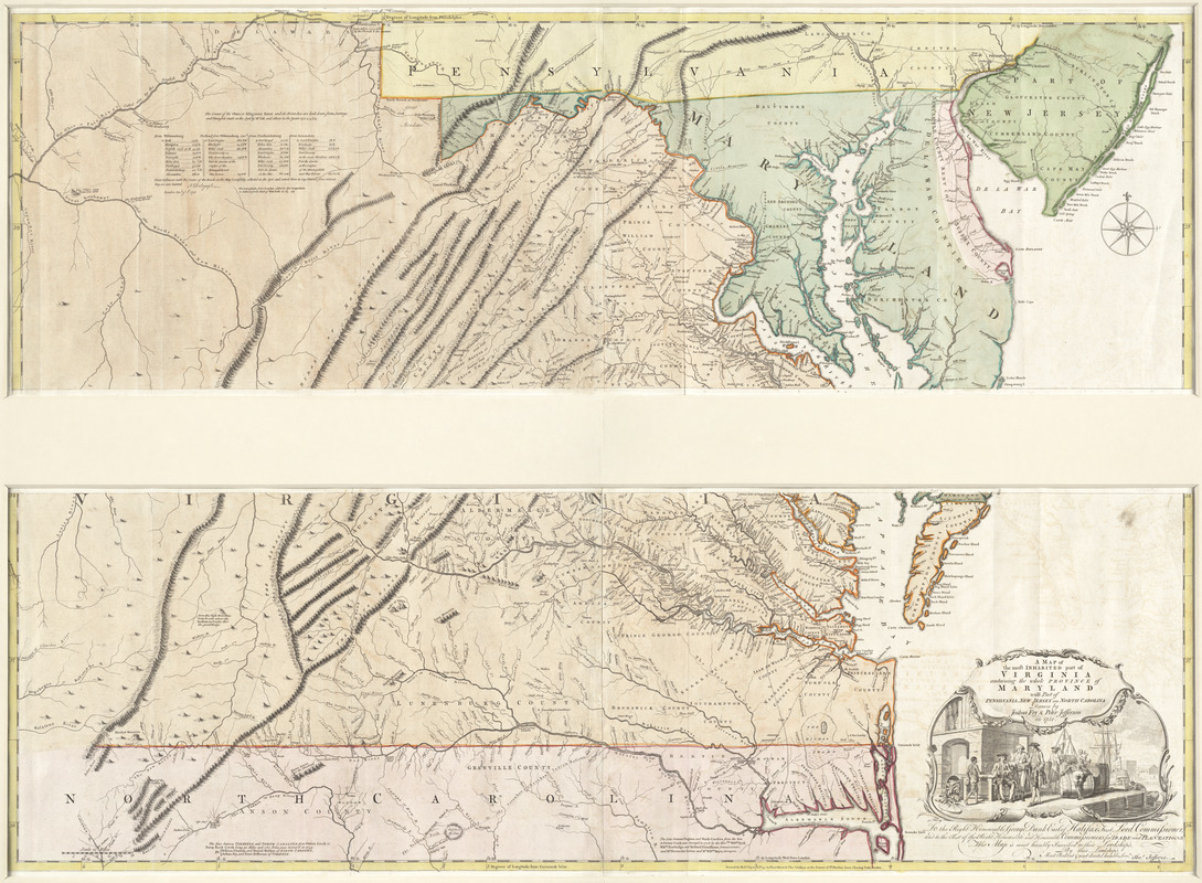
A map of the most inhabited part of Virginia containing the whole province of Maryland with part of Pensilvania, New Jersey and North Carolina
This map is also available in American Revolutionary Geographies Online (ARGO), a collections portal especially built for material relating to the American Revolutionary War Era. Visit ARGO to learn more about this item and explore the historical geography of North America in the late eighteenth century.
Item Information
- Title:
- A map of the most inhabited part of Virginia containing the whole province of Maryland with part of Pensilvania, New Jersey and North Carolina
- Description:
-
Joshua Fry (Albemarle County surveyor) and his deputy, Peter Jefferson (Thomas Jefferson's father), compiled this map in 1751 at the request of the Board of Trade. Based on their extensive experience surveying the Virginia-North Carolina boundary and Northern Neck Proprietary land grants, the map provided substantially new information about the mountain ranges and rivers in the western part of Virginia. This map remained the most authoritative map of the Chesapeake region for the rest of the 18th century, appearing in eight English and five French editions. John Mitchell used this map as he prepared his 1755 map of North America.
- Creator:
- Fry, Joshua, 1700 (ca.)-1754, 1700 (ca.)-1754
- Author:
- Jefferson, Peter, 1708-1757
- Contributor:
- Sayer, Robert, 1725-1794
- Publisher:
- Jefferys, Thomas, -1771
- Name on Item:
-
drawn by Joshua Fry & Peter Jefferson in 1751
- Date:
-
[1768]
- Format:
-
Maps/Atlases
- Location:
- George Washington's Mount Vernon
- Collection (local):
-
Richard H. Brown Revolutionary War Map Collection at Mount Vernon
- Subjects:
-
Indians of North America--Middle Atlantic States--Maps--Early works to 1800
Virginia--Maps--Early works to 1800
Maryland--Maps--Early works to 1800
Middle Atlantic States--Maps--Early works to 1800
- Places:
-
Middle Atlantic (area)
- Extent:
- 1 map on 4 sheets ; 76 x 123 cm., on sheets 55 x 73 cm.
- Terms of Use:
-
No known copyright restrictions.
This work is licensed for use under a Creative Commons Attribution Non-Commercial Share Alike License (CC BY-NC-SA).

- Publisher:
-
London :
Printed for Robt. Sayer ... & Thos. Jefferys
- Scale:
-
Scale [ca. 1:650,000]
- Language:
-
English
- Catalog Record:
-
MVLA record
- Notes:
-
Prime meridians: Philadelphia, Curratuck Inlet, and London.
Relief shown pictorially.
"To the Right Honourable, George Dunk Earl of Halifax ... [by] Thos. Jefferys."
Includes notes and distance chart.
Appears in Jefferys' General topography of North America and the West Indies. London: Printed for Robert Sayer, ... and Thomas Jefferys, 1768.
This map can be viewed as a georeferenced overlay in an interactive application made especially for We Are One: Mapping America's Road from Revolution to Independence http://d2o8owo4k087al.cloudfront.net/index.html?mapId=35.
- Notes (date):
-
This date is inferred.
- Notes (citation):
-
LC Maps of North America, 1750-1789, 1429
Stevens & Tree. Comparative cartography, 87e
- Notes (exhibitions):
-
Exhibited: "We Are One: Mapping America's Road from Revolution to Independence" organized by the Norman B. Leventhal Map Center at the Boston Public Library, 2015.
- Identifier:
-
06_01_009611
- Barcode:
-
30000003873383


