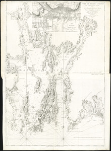
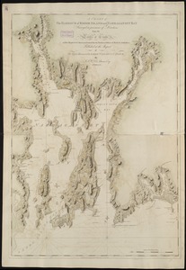
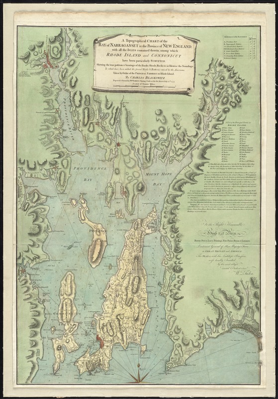
A topographical chart of the bay of Narraganset in the province of New England : with all the isles contained therein, among which Rhode Island and Connonicut have been particularly surveyed ; shewing the true position & bearings of the banks, shoals, rocks &c. as likewise the soundings ; to which have been added the several works & batteries raised by the Americans ; taken by order of the principal farmers on Rhode Island
This map is also available in American Revolutionary Geographies Online (ARGO), a collections portal especially built for material relating to the American Revolutionary War Era. Visit ARGO to learn more about this item and explore the historical geography of North America in the late eighteenth century.
Item Information
- Title:
- A topographical chart of the bay of Narraganset in the province of New England : with all the isles contained therein, among which Rhode Island and Connonicut have been particularly surveyed ; shewing the true position & bearings of the banks, shoals, rocks &c. as likewise the soundings ; to which have been added the several works & batteries raised by the Americans ; taken by order of the principal farmers on Rhode Island
- Creator:
- Blaskowitz, Charles.
- Name on Item:
-
by Charles Blaskowitz ; engraved & printed for Wm. Faden.
- Date:
-
1777
- Format:
-
Maps/Atlases
- Location:
- George Washington's Mount Vernon
- Collection (local):
-
Richard H. Brown Revolutionary War Map Collection at Mount Vernon
- Subjects:
-
Nautical charts--Rhode Island--Narragansett Bay--Early works to 1800
Narragansett Bay (R.I.)--History--18th century--Maps--Early works to 1800
Rhode Island--Defenses--Maps--Early works to 1800
- Places:
-
Bristol (county)Narragansett Bay
- Extent:
- 1 map : hand col. ; 92 x 63 cm.
- Terms of Use:
-
No known copyright restrictions.
This work is licensed for use under a Creative Commons Attribution Non-Commercial Share Alike License (CC BY-NC-SA).

- Publisher:
-
[London] :
Wm. Faden
- Scale:
-
Scale [ca. 1:50,500]
- Language:
-
English
- Catalog Record:
-
MVLA record
- Notes:
-
Relief shown by hachures. Depths shown by soundings.
Inscribed "To the Right Honourable Hugh Earl Percy ... with His Lordship's permission ... by ... Wm. Faden."
Includes text, "References to the batteries," and "A list of the principal farms in Rhode Island."
This map can be viewed as a georeferenced overlay in an interactive application made especially for We Are One: Mapping America's Road from Revolution to Independence http://d2o8owo4k087al.cloudfront.net/index.html?mapId=65.
- Identifier:
-
06_01_009575
- Barcode:
-
30000003867845