A map of the north west parts of the United States of America
This map is also available in American Revolutionary Geographies Online (ARGO), a collections portal especially built for material relating to the American Revolutionary War Era. Visit ARGO to learn more about this item and explore the historical geography of North America in the late eighteenth century.
Item Information
- Title:
- A map of the north west parts of the United States of America
- Description:
-
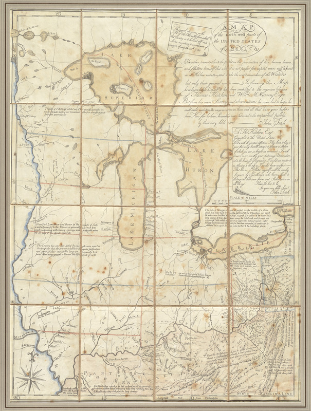
This rare and unique map was produced by inventor and amateur mapmaker John Fitch, in an attempt to raise funds to support his newly invented steamboat. Fitch made and engraved the map himself, and printed it in Philadelphia on a cider press. Unfortunately for Fitch, the map never sold well, and the geography displayed on the map was well out-of-date by the time the Old Northwest was settled after being released from British and Native American control.
- Creator:
- Fitch, John, 1743-1798
- Name on Item:
-
John Fitch.
- Date:
-
[1785]
- Format:
-
Maps/Atlases
- Location:
- George Washington's Mount Vernon
- Collection (local):
-
Richard H. Brown Revolutionary War Map Collection at Mount Vernon
- Subjects:
-
Northwest, Old--Maps--Early works to 1800--Facsimiles
Northwest, Old--Administrative and political divisions--Maps--Early works to 1800
Hutchins, Thomas, 1730-1789
- Places:
-
Midwest (area)
- Extent:
- 1 map : hand col. ; 68 x 50 cm.
- Terms of Use:
-
No known copyright restrictions.
This work is licensed for use under a Creative Commons Attribution Non-Commercial Share Alike License (CC BY-NC-SA).

- Publisher:
-
[S.l.] :
John Fitch
- Scale:
-
Scale [ca. 1:2,550,000]
- Language:
-
English
- Catalog Record:
-
MVLA record
- Notes:
-
Shows Great Lakes to North Carolina and the Mississippi River to the Allegany and part of Lake Ontario.
Prime meridian: Philadelphia.
Relief shown by landform drawing.
Dedication to Thos. Hutchins Esqr.
"The several divisions on the N.W. of the Ohio is the form which that Country is to be laid off into states according to the oridinance of Congress of May the 20th 1785."
Includes notes.
- Notes (date):
-
This date is inferred.
- Identifier:
-
06_01_009559

![[A map of part of Pennsylvania & Maryland intended to shew, at one view, the several places proposed for opening a communication between the waters of the Delaware & Chesopeak Bays]](https://bpldcassets.blob.core.windows.net/derivatives/images/commonwealth:z603vt12v/image_thumbnail_300.jpg)


