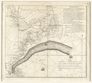
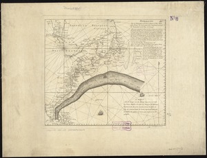
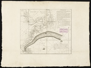
[Chart of the Gulf Stream]
![[Chart of the Gulf Stream]](https://bpldcassets.blob.core.windows.net/derivatives/images/commonwealth:z603vr47j/image_access_800.jpg)
This map is also available in American Revolutionary Geographies Online (ARGO), a collections portal especially built for material relating to the American Revolutionary War Era. Visit ARGO to learn more about this item and explore the historical geography of North America in the late eighteenth century.
Item Information
- Title:
- [Chart of the Gulf Stream]
- Name on Item:
-
Jones sc.
- Date:
-
[1799]
- Format:
-
Maps/Atlases
- Location:
- George Washington's Mount Vernon
- Collection (local):
-
Richard H. Brown Revolutionary War Map Collection at Mount Vernon
- Subjects:
-
Nautical charts--Gulf Stream--Early works to 1800
Gulf Stream--Maps
Atlantic Ocean--Maps
- Places:
-
Atlantic Ocean
- Extent:
- 1 map ; 31 x 47 cm.
- Terms of Use:
-
No known copyright restrictions.
This work is licensed for use under a Creative Commons Attribution Non-Commercial Share Alike License (CC BY-NC-SA).

- Publisher:
-
Philadelphia :
[s.n.]
- Scale:
-
Scale [ca. 1:17,400,000]
- Language:
-
English
- Notes:
-
Shows ship courses and ocean currents.
Prime meridians: London and Ferro.
Depth shown by soundings.
In upper right: Plate IV.
- Notes (date):
-
This date is inferred.
- Identifier:
-
06_01_009564