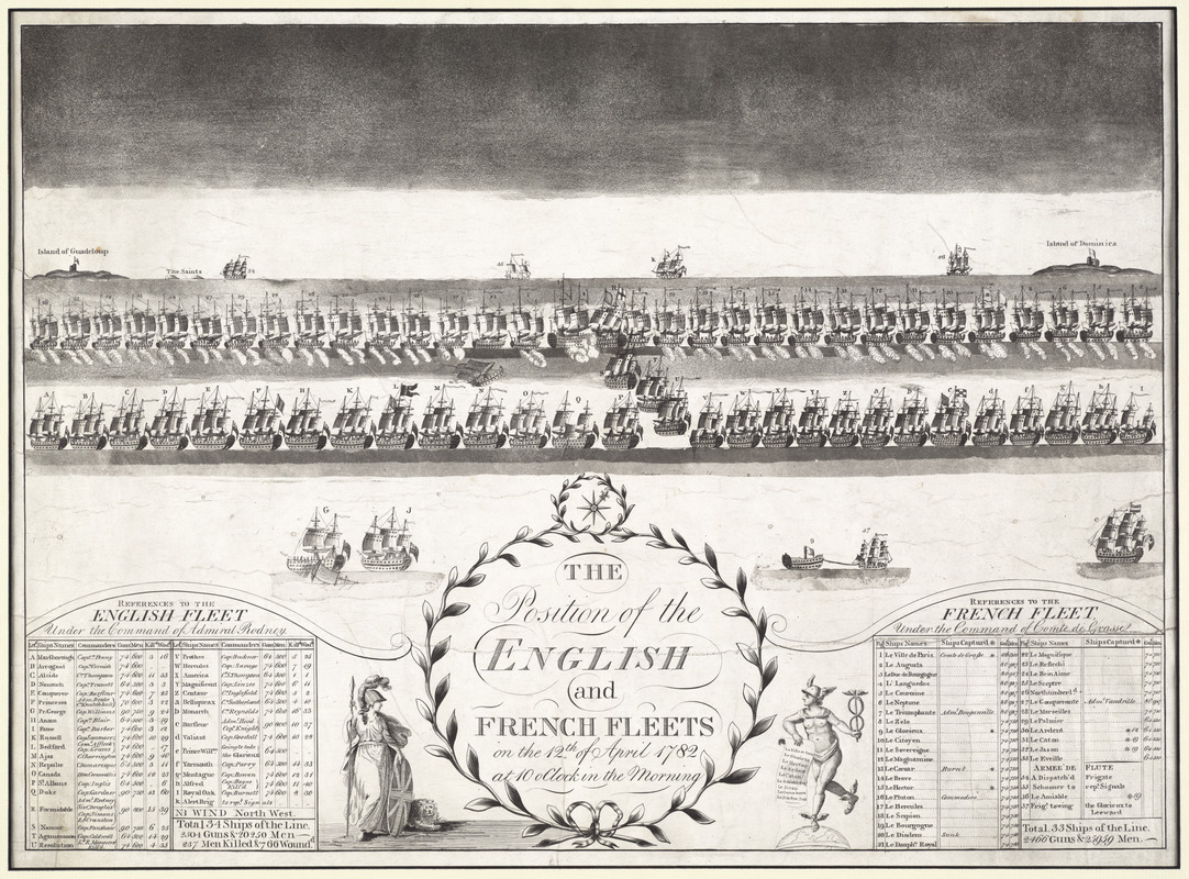
The position of the English and French fleets on the 12th of April 1782 at 10 oclock in the morning
This map is also available in American Revolutionary Geographies Online (ARGO), a collections portal especially built for material relating to the American Revolutionary War Era. Visit ARGO to learn more about this item and explore the historical geography of North America in the late eighteenth century.
Item Information
- Title:
- The position of the English and French fleets on the 12th of April 1782 at 10 oclock in the morning
- Description:
-
This image depicts the position of the English and French ships during the 1782 Battle of the Saintes. The Americans had defeated the British at Yorktown in 1781, but the British continued their fight to maintain the rest of their colonies. The British victory at this battle, which occurred near the Îles des Saintes, prevented the French from taking control of Jamaica. Near the English fleet list, a female figure with a spear and shield, called Britannia, symbolizes the empire. The ship labeled "T" in the middle of this map represents the Agamemnon. The British ship the Agamemnon was named after the mythological king who led the Greeks during the Trojan War. Nicknamed Eggs-and-Bacon, the Agamemnon was a third rate ship of the line with 64 guns and a staff of nearly 500 people. Commissioned in 1781, the Royal Navy used this ship to maintain and build their empire until she sank in 1809. The ship joined the West Indies fleet after a successful engagement off the coast of France.
- Date:
-
[1782?]
- Format:
-
Prints
- Genre:
-
Views
- Location:
- George Washington's Mount Vernon
- Collection (local):
-
Richard H. Brown Revolutionary War Map Collection at Mount Vernon
- Subjects:
-
Saintes, Battle of the, Guadeloupe, 1782--Pictorial works--Early works to 1800
Saintes Islands (Guadeloupe)--History--Revolution, 1775-1783--Pictorial works--Early works to 1800
Dominica--History--Revolution, 1775-1783--Pictorial works--Early works to 1800
- Places:
-
Saintes, Îles des (area)
Dominica
- Extent:
- 1 view ; 50 x 68 cm.
- Terms of Use:
-
No known copyright restrictions.
This work is licensed for use under a Creative Commons Attribution Non-Commercial Share Alike License (CC BY-NC-SA).

- Publisher:
-
[S.l.] :
[s.n.]
- Scale:
-
Not drawn to scale
- Language:
-
English
- Catalog Record:
-
MVLA record
- Notes:
-
Panoramic view English and French ships on the final day of the Battle of the Saintes.
Includes references to ships in the fleets.
- Notes (exhibitions):
-
Exhibited: "We Are One: Mapping America's Road from Revolution to Independence" organized by the Norman B. Leventhal Map Center at the Boston Public Library, 2015.
- Identifier:
-
06_01_009543

![[A map of part of Pennsylvania & Maryland intended to shew, at one view, the several places proposed for opening a communication between the waters of the Delaware & Chesopeak Bays]](https://bpldcassets.blob.core.windows.net/derivatives/images/commonwealth:z603vt12v/image_thumbnail_300.jpg)


