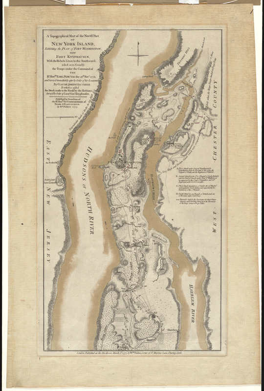
A topographical map of the northn. part of New York Island, exhibiting the plan of Fort Washington, now Fort Knyphausen, with the rebels lines to the southward, which were forced by the troops under the command of the Rt. Honble. Earl Percy, on the 16th Novr. 1776, and survey'd immediately after by order of his Lordship
This map is also available in American Revolutionary Geographies Online (ARGO), a collections portal especially built for material relating to the American Revolutionary War Era. Visit ARGO to learn more about this item and explore the historical geography of North America in the late eighteenth century.
Item Information
- Title:
- A topographical map of the northn. part of New York Island, exhibiting the plan of Fort Washington, now Fort Knyphausen, with the rebels lines to the southward, which were forced by the troops under the command of the Rt. Honble. Earl Percy, on the 16th Novr. 1776, and survey'd immediately after by order of his Lordship
- Creator:
- Sauthier, Claude Joseph
- Name on Item:
-
by Claude Joseph Sauthier, to which is added the attack made to the northd. by the Hessians survey'd by order of Lieut. Genl. Knyphausen.
- Date:
-
1777
- Format:
-
Maps/Atlases
- Location:
- George Washington's Mount Vernon
- Collection (local):
-
Richard H. Brown Revolutionary War Map Collection at Mount Vernon
- Subjects:
-
New York (N.Y.)--History--Revolution, 1775-1783--Maps--Early works to 1800
Fort Washington (New York, N.Y.)--History--18th century--Maps--Early works to 1800
Fort Washington (New York, N.Y.)--Capture, 1776--Maps--Early works to 1800
- Places:
-
New York
- Extent:
- 1 map : hand col. ; 47 x 26 cm.
- Terms of Use:
-
No known copyright restrictions.
This work is licensed for use under a Creative Commons Attribution Non-Commercial Share Alike License (CC BY-NC-SA).

- Publisher:
-
London :
Wm. Faden
- Scale:
-
Scale [ca. 1:21,000]
- Language:
-
English
- Catalog Record:
-
MVLA record
- Notes:
-
Relief shown by hachures.
"Published by permission of the Rt. Honble. the Commissioners of Trade & Plantations, by Wm. Faden, 1777."
Includes references.
Variant state labeling columns and showing units northwest of Snake Hill.
- Identifier:
-
06_01_009544