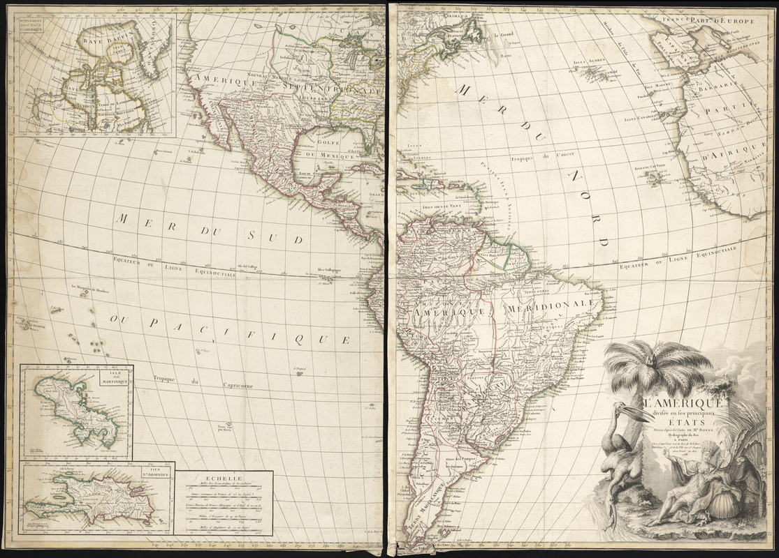
L'Amerique divisée en ses principaux États
This map is also available in American Revolutionary Geographies Online (ARGO), a collections portal especially built for material relating to the American Revolutionary War Era. Visit ARGO to learn more about this item and explore the historical geography of North America in the late eighteenth century.
Item Information
- Title:
- L'Amerique divisée en ses principaux États
- Title (alt.):
-
Amerique divisée en ses principaux États
- Description:
-
This general map of the Americas, produced in Paris in 1788, depicts the political divisions in North America just after the Treaty of Paris was signed in 1783. The Treaty effectively ended the American Revolutionary War. The United States is comprised of land east of the Mississippi River, while Great Britain controls Canada and Spain controls Louisiana, Mexico, Florida and western North America. Also depicted is a large inset of the Canadian Arctic, and another two insets of Caribbean islands, in addition to an elaborately illustrated cartouche.
- Creator:
- Bonne, Rigobert, 1727-1794
- Publisher:
- Lattré, Jean
- Name on Item:
-
dressée d'après des cartes de Mr. Bonne.
- Date:
-
1788
- Format:
-
Maps/Atlases
- Location:
- George Washington's Mount Vernon
- Collection (local):
-
Richard H. Brown Revolutionary War Map Collection at Mount Vernon
- Subjects:
-
America--Maps--Early works to 1800
Western Hemisphere--Maps--Early works to 1800
- Places:
-
North America (area)
South America
Mesoamerica (area)
- Extent:
- 1 map on 2 sheets : hand col. ; 72 x 100 cm, sheets 73 x 52 cm.
- Terms of Use:
-
No known copyright restrictions.
This work is licensed for use under a Creative Commons Attribution Non-Commercial Share Alike License (CC BY-NC-SA).

- Publisher:
-
A Paris :
Chez Lattré
- Scale:
-
Scale [ca. 1:14,000,000]
- Language:
-
French
- Catalog Record:
-
MVLA record
- Notes:
-
Map of the Americas designed to show the political divisions in North America immediately following the Treaty of Paris.
Relief shown pictorially.
Insets: Supplement pour le Nord de L'Amerique ; Isle de la Martinique ; Isle St. Domingue.
Elaborate cartouche in lower left.
- Identifier:
-
06_01_008525


