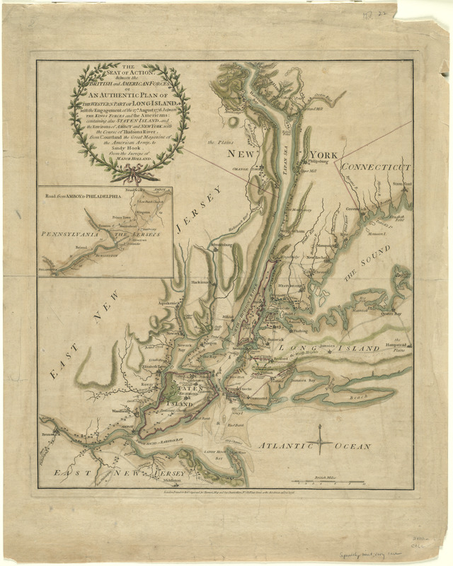
The seat of action, between the British and American forces : or an authentic plan of the western part of Long Island, with the engagement of the 27th August 1776 between the King's forces and the Americans : containing also Staten Island, and the environs of Amboy and New York, with the course of Hudsons River, from Courtland the great magazine of the American Army, to Sandy Hook
This map is also available in American Revolutionary Geographies Online (ARGO), a collections portal especially built for material relating to the American Revolutionary War Era. Visit ARGO to learn more about this item and explore the historical geography of North America in the late eighteenth century.
Item Information
- Title:
- The seat of action, between the British and American forces : or an authentic plan of the western part of Long Island, with the engagement of the 27th August 1776 between the King's forces and the Americans : containing also Staten Island, and the environs of Amboy and New York, with the course of Hudsons River, from Courtland the great magazine of the American Army, to Sandy Hook
- Title (alt.):
-
Authentic plan of the western part of Long Island, with the engagement of the 27th August 1776 between the King's forces and the Americans
- Description:
-
The map displayed here was printed as a separate issue, as it contained recent information regarding the the British campaign to take New York City. Printed as a broadside, the information could be transmitted in a timely manner - in this case, two months after the events depicted on the map. After an embarrassing defeat at Bunker Hill in Charlestown, MA, Britain was eager to transmit the news of this victory in New York in November 1776 to an eager audience back in England.
- Creator:
- Holland, Samuel, 1728-1801
- Contributor:
- Robert Sayer and John Bennett (Firm)
- Name on Item:
-
from the surveys of Major Holland.
- Date:
-
1776
- Format:
-
Maps/Atlases
- Location:
- George Washington's Mount Vernon
- Collection (local):
-
Richard H. Brown Revolutionary War Map Collection at Mount Vernon
- Subjects:
-
Long Island, Battle of, New York, N.Y., 1776--Maps--Early works to 1800
Middle Atlantic States--History--Revolution, 1775-1783--Maps--Early works to 1800
Long Island (N.Y.)--History--Revolution, 1775-1783--Maps--Early works to 1800
Staten Island (New York, N.Y.)--History--18th century--Maps--Early works to 1800
- Places:
-
Richmond (county)Staten Island (island)
Middle Atlantic (area)
- Extent:
- 1 map : hand col. ; 45 x 39 cm.
- Terms of Use:
-
No known copyright restrictions.
This work is licensed for use under a Creative Commons Attribution Non-Commercial Share Alike License (CC BY-NC-SA).

- Publisher:
-
London :
Printed for Robt. Sayer and Jno. Bennett
- Scale:
-
Scale [ca. 1:215,000]
- Language:
-
English
- Catalog Record:
-
MVLA record
- Notes:
-
Relief shown by hachures.
Has watermarks.
Inset: Road from Amboy to Philadelphia.
- Identifier:
-
06_01_008237
- LCCN:
-
gm 71002199


