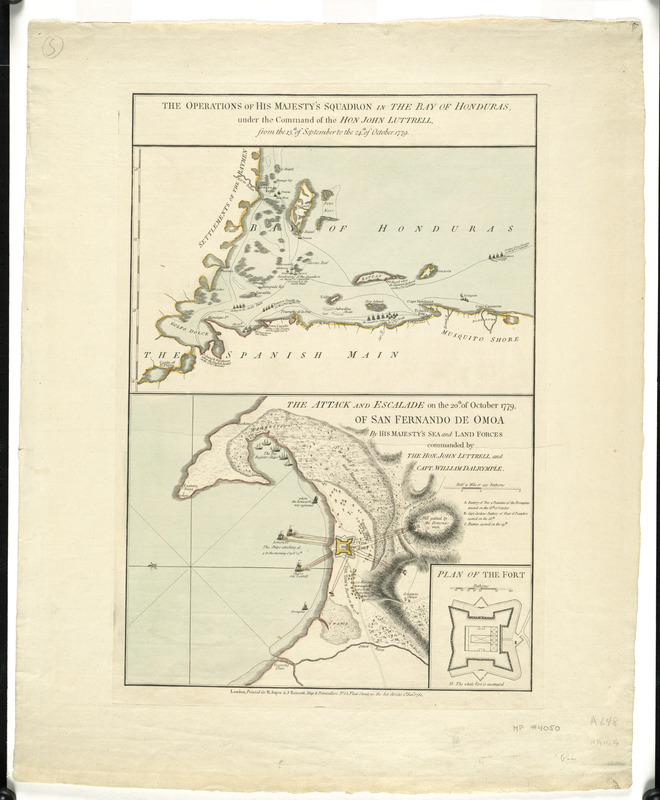
The operations of His Majesty's squadron in the Bay of Honduras, under the command of the Hon. John Luttrell from the 15th of September to the 24th of October 1779
This map is also available in American Revolutionary Geographies Online (ARGO), a collections portal especially built for material relating to the American Revolutionary War Era. Visit ARGO to learn more about this item and explore the historical geography of North America in the late eighteenth century.
Item Information
- Title:
- The operations of His Majesty's squadron in the Bay of Honduras, under the command of the Hon. John Luttrell from the 15th of September to the 24th of October 1779
- Title (alt.):
-
Attack and escalade on the 20th. of October 1779, of San Fernando de Omoa by His Majesty's sea and land forces commanded by the Hon. John Luttrell and Capt. William Dalrymple
- Contributor:
- Robert Sayer and John Bennett (Firm)
- Date:
-
1780
- Format:
-
Maps/Atlases
- Location:
- George Washington's Mount Vernon
- Collection (local):
-
Richard H. Brown Revolutionary War Map Collection at Mount Vernon
- Subjects:
-
Fortaleza de San Fernando (Omoa, Cortés, Honduras)--History--Revolution, 1775-1783--Maps--Early works to 1800
Honduras, Gulf of--History--Revolution, 1775-1783--Maps--Early works to 1800
- Places:
-
CortésOmoa
Honduras, Gulf of
- Extent:
- 2 maps on 1 sheet : hand col. ; sheet 48 x 33 cm.
- Terms of Use:
-
No known copyright restrictions.
This work is licensed for use under a Creative Commons Attribution Non-Commercial Share Alike License (CC BY-NC-SA).

- Publisher:
-
London :
R. Sayer & J. Bennett
- Scale:
-
Scale [ca. 1:32,000]
Scale [ca. 1:12,750]
- Language:
-
English
- Catalog Record:
-
MVLA record
- Notes:
-
Shows operations and ship names.
Map of Omoa oriented with north to the left.
Relief shown by hachures.
Inset: Plan of the fort.
- Identifier:
-
06_01_008238

![[A map of part of Pennsylvania & Maryland intended to shew, at one view, the several places proposed for opening a communication between the waters of the Delaware & Chesopeak Bays]](https://bpldcassets.blob.core.windows.net/derivatives/images/commonwealth:z603vt12v/image_thumbnail_300.jpg)


