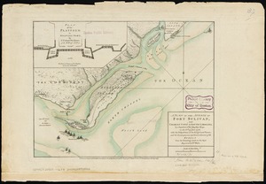
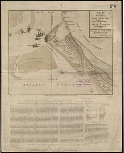
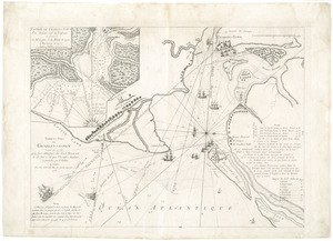
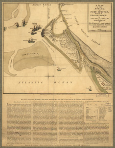
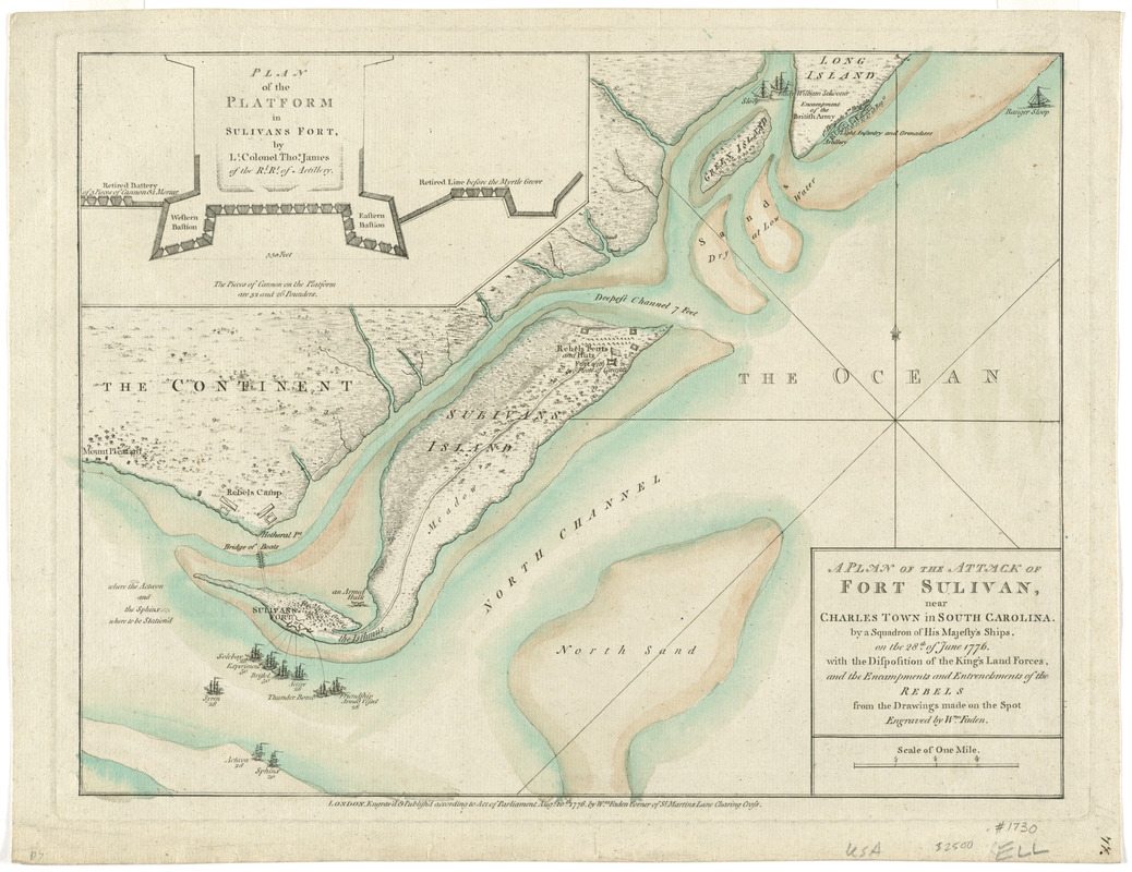
A plan of the attack of Fort Sulivan, near Charles Town in South Carolina : by a squadron of His Majesty's ships, on the 28th of June 1776, with the disposition of the King's land forces, and the encampments and entrenchments of the rebels from the drawings made on the spot
This map is also available in American Revolutionary Geographies Online (ARGO), a collections portal especially built for material relating to the American Revolutionary War Era. Visit ARGO to learn more about this item and explore the historical geography of North America in the late eighteenth century.
Item Information
- Title:
- A plan of the attack of Fort Sulivan, near Charles Town in South Carolina : by a squadron of His Majesty's ships, on the 28th of June 1776, with the disposition of the King's land forces, and the encampments and entrenchments of the rebels from the drawings made on the spot
- Creator:
- Faden, William, 1749-1836
- Name on Item:
-
engraved by Wm. Faden.
- Date:
-
1776
- Format:
-
Maps/Atlases
- Location:
- George Washington's Mount Vernon
- Collection (local):
-
Richard H. Brown Revolutionary War Map Collection at Mount Vernon
- Subjects:
-
Fort Moultrie, Battle of, S.C., 1776--Maps--Early works to 1800
Fortification--South Carolina--Maps--Early works to 1800
Fort Moultrie (S.C.)--History--Revolution, 1775-1783--Maps--Early works to 1800
Fort Sullivan (S.C.)--History--Revolution, 1775-1783--Maps--Early works to 1800
- Places:
-
Charleston (county)Charleston
- Extent:
- 1 map : hand col. ; 28 x 38 cm.
- Terms of Use:
-
No known copyright restrictions.
This work is licensed for use under a Creative Commons Attribution Non-Commercial Share Alike License (CC BY-NC-SA).

- Publisher:
-
London :
Wm. Faden
- Scale:
-
Scale [ca.1:26,000]
- Language:
-
English
- Catalog Record:
-
MVLA record
- Notes:
-
Depth shown by soundings.
Inset: Plan of the platform in Sulivans Fort / by Lt. Colonel Thos. James of the Rl. Rt. of Artillery.
Shows British squadron including names of vessels, esp. "bridge of boats" at Hetheral pt.", rebel camps, and vegetation.
Below lower margin: "London. Engrav'd & Publish'd according to Acto of Parliament Aug.t 10 th. 1776 by Wm. Faden corner of St. Martins Lane Charing Cross."
Includes description of symbols for where the Actoeon and the Sphinx were to be Stationed.
Third state of the map with a single "bridge of boats" between Hetheral Pt. and the island.
- Identifier:
-
06_01_008214