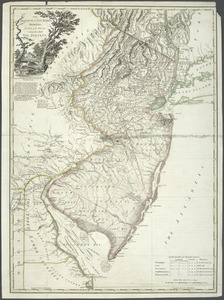
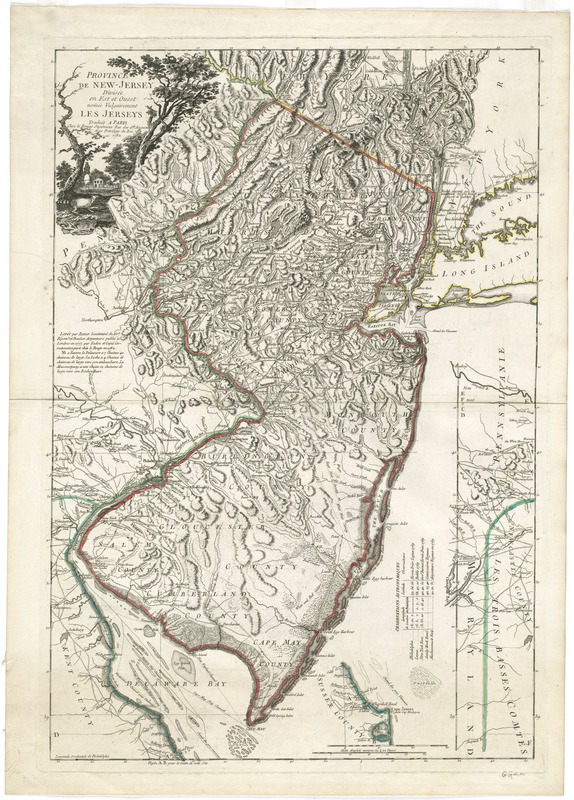
Province de New-Jersey divisée en est et ouest nomée vulgairement les Jerseys
This map is also available in American Revolutionary Geographies Online (ARGO), a collections portal especially built for material relating to the American Revolutionary War Era. Visit ARGO to learn more about this item and explore the historical geography of North America in the late eighteenth century.
Item Information
- Title:
- Province de New-Jersey divisée en est et ouest nomée vulgairement les Jerseys
- Creator:
- Le Rouge, Georges-Louis
- Contributor:
- Faden, William, 1749-1836
- Contributor:
- Ratzer, Bernard
- Contributor:
- Bancker, Gerard, 1740-1799
- Name on Item:
-
traduit a Paris Chez Le Rouge.
- Date:
-
1782
- Format:
-
Maps/Atlases
- Location:
- George Washington's Mount Vernon
- Collection (local):
-
Richard H. Brown Revolutionary War Map Collection at Mount Vernon
- Subjects:
-
New Jersey--Maps--Early works to 1800
New Jersey--Administrative and political divisions--Maps--Early works to 1800
- Places:
-
New Jersey
- Extent:
- 1 map : hand col. ; 71 x 48 cm.
- Terms of Use:
-
No known copyright restrictions.
This work is licensed for use under a Creative Commons Attribution Non-Commercial Share Alike License (CC BY-NC-SA).

- Publisher:
-
Paris :
Chez Le Rouge
- Scale:
-
Scale [ca. 1:432,000]
- Language:
-
French
- Catalog Record:
-
MVLA record
- Notes:
-
Prime meridian: Philadelphia.
Relief shown by hachures.
Shows county boundaries, division tracée en 1746, and division de Keith en 1687.
Includes table of "Observations astronomiques."
Includes continuation insets of the left and lower parts of the map.
"Levée par Ratzer Lieutenant du 60e Régimt. et Banker Arpenteurs publié ả Londres en 1777, par Faden et copié correctement a Paris chèz Le Rouge en 1782."
Decorative title cartouche depicting the countryside.
In French.
- Identifier:
-
06_01_008213