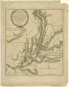
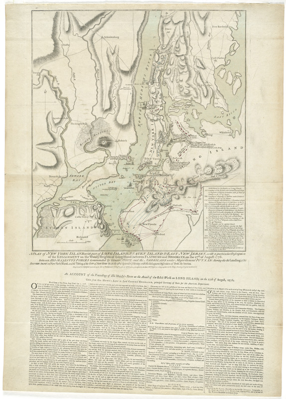
A plan of New York Island, with part of Long Island, Staten Island & east New Jersey, with a particular description of the engagement on the Woody Heights of Long Island, between Flatbush and Brooklyn, on the 27th of August 1776 : between His Majesty's forces commanded by General Howe and the Americans under Major General Putnam, shewing also the landing of the British Army on New-York Island, and the taking of the city of New-York &c. on the 15th of September following, with the subsequent disposition of both the armies
This map is also available in American Revolutionary Geographies Online (ARGO), a collections portal especially built for material relating to the American Revolutionary War Era. Visit ARGO to learn more about this item and explore the historical geography of North America in the late eighteenth century.
Item Information
- Title:
- A plan of New York Island, with part of Long Island, Staten Island & east New Jersey, with a particular description of the engagement on the Woody Heights of Long Island, between Flatbush and Brooklyn, on the 27th of August 1776 : between His Majesty's forces commanded by General Howe and the Americans under Major General Putnam, shewing also the landing of the British Army on New-York Island, and the taking of the city of New-York &c. on the 15th of September following, with the subsequent disposition of both the armies
- Description:
-
Published just weeks after the events depicted on it, William Faden's plan of New York Island shows the American in British forces as they were stationed in August 1776. Known as the "Faden Campaign Map," the plan details Gen. Howe's tactics and progress of events, but minimizes the activities of the Americans, including the successful movement of Washington's men from Brooklyn Heights to Manhattan the night of August 29. Displayed here is state 5 of the map, with Fort Lee or Ft. Constitution added and Younkers unlabeled.
- Creator:
- Faden, William, 1749-1836
- Name on Item:
-
engraved & publish'd ... by Wm. Faden.
- Date:
-
1776
- Format:
-
Maps/Atlases
- Location:
- George Washington's Mount Vernon
- Collection (local):
-
Richard H. Brown Revolutionary War Map Collection at Mount Vernon
- Subjects:
-
Long Island, Battle of, New York, N.Y., 1776--Maps--Early works to 1800
New York (N.Y.)--History--Revolution, 1775-1783--Maps--Early works to 1800
Long Island (N.Y.)--History--Revolution, 1775-1783--Maps--Early works to 1800
Staten Island (New York, N.Y.)--History--18th century--Maps--Early works to 1800
- Places:
-
Richmond (county)Staten Island (island)
- Extent:
- 1 map : hand col. ; 48 x 43 cm.
- Terms of Use:
-
No known copyright restrictions.
This work is licensed for use under a Creative Commons Attribution Non-Commercial Share Alike License (CC BY-NC-SA).

- Publisher:
-
London :
Wm. Faden
- Scale:
-
Scale [ca. 1:84,000]
- Language:
-
English
- Catalog Record:
-
MVLA record
- Notes:
-
Relief shown by hachures.
Depths shown by soundings.
Shows information to Sept. 3, 1776.
Below map: An account of the proceedings of His Majesty's forces at the attack of the rebel works on Long Island, on the 27th of August, 1776 : taken from Gen. Howe's letter to Lord George Germaine, principal Secretary of State for the American Department."
State 5 of the map, with Fort Lee or Ft. Constitution added and Younkers unlabeled.
- Identifier:
-
06_01_008156
- LCCN:
-
gm 71000865