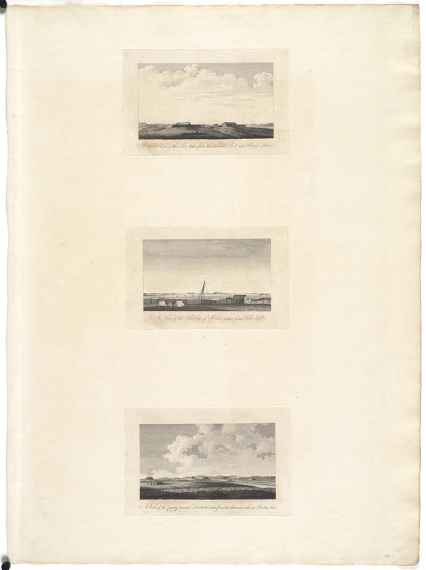
A front view of the lines taken from the advanced post near Browns house : A view of the harbour of Boston taken from Fort Hill ; A view of the country towards Dorchester, taken from the advanced works on Boston Neck
This map is also available in American Revolutionary Geographies Online (ARGO), a collections portal especially built for material relating to the American Revolutionary War Era. Visit ARGO to learn more about this item and explore the historical geography of North America in the late eighteenth century.
Item Information
- Title:
- A front view of the lines taken from the advanced post near Browns house : A view of the harbour of Boston taken from Fort Hill ; A view of the country towards Dorchester, taken from the advanced works on Boston Neck
- Title (alt.):
-
View of the harbour of Boston taken from Fort Hill
View of the country towards Dorchester, taken from the advanced works on Boston neck
- Creator:
- Des Barres, Joseph F. W. (Joseph Frederick Wallet), 1722-1824
- Date:
-
[1775?]
- Format:
-
Prints
- Genre:
-
Views
- Location:
- George Washington's Mount Vernon
- Collection (local):
-
Richard H. Brown Revolutionary War Map Collection at Mount Vernon
- Subjects:
-
Boston Harbor (Mass.)--Pictorial works--Early works to 1800
Dorchester (Boston, Mass.)--Pictorial works--Early works to 1800
- Places:
-
Boston Harbor
Suffolk (county)BostonDorchester
- Extent:
- 3 views on 1 sheet ; each 12 x 21 cm., on sheet 85 x 63 cm.
- Terms of Use:
-
No known copyright restrictions.
This work is licensed for use under a Creative Commons Attribution Non-Commercial Share Alike License (CC BY-NC-SA).

- Publisher:
-
London :
J.F.W. Des Barres
- Scale:
-
Not drawn to scale
- Language:
-
English
- Catalog Record:
-
MVLA record
- Notes:
-
Three views of Boston by J.F.W. Des Barres created prior to, or just after the beginning of the Revolutionary war; some showing military emplacements by British officers; from Des Barres's Atlantic Neptune.
- Identifier:
-
06_01_008503


![[A map of part of Pennsylvania & Maryland intended to shew, at one view, the several places proposed for opening a communication between the waters of the Delaware & Chesopeak Bays]](https://bpldcassets.blob.core.windows.net/derivatives/images/commonwealth:z603vt12v/image_thumbnail_300.jpg)
