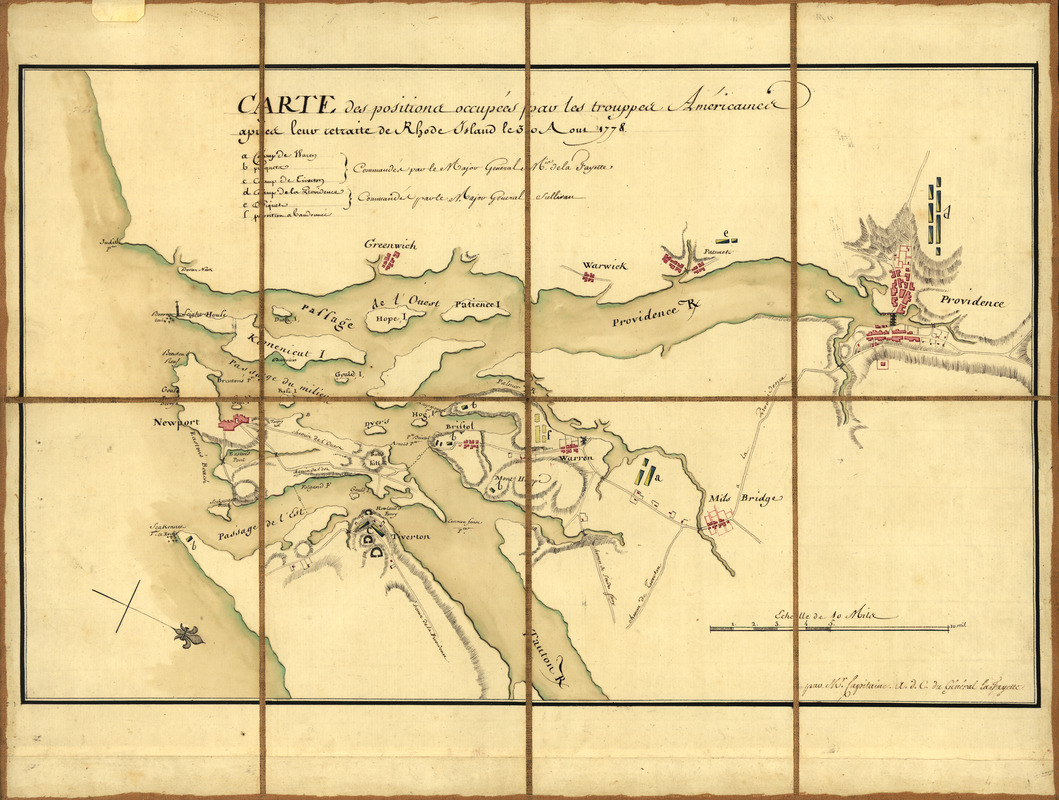
Carte des positions occupeés par les trouppes Américaines apres leur retraite de Rhode Island le 30 Aout 1778
This map is also available in American Revolutionary Geographies Online (ARGO), a collections portal especially built for material relating to the American Revolutionary War Era. Visit ARGO to learn more about this item and explore the historical geography of North America in the late eighteenth century.
Item Information
- Title:
- Carte des positions occupeés par les trouppes Américaines apres leur retraite de Rhode Island le 30 Aout 1778
- Creator:
- Capitaine du Chesnoy, Michel, 1746-1804
- Contributor:
- Lafayette, Marie Joseph Paul Yves Roch Gilbert Du Motier, marquis de, 1757-1834
- Name on Item:
-
par Mr. Capitaine, a. d. C. du Général la Fayette
- Date:
-
[1778]
- Format:
-
Maps/Atlases
Manuscripts
- Location:
- Library of Congress Geography and Map Division
- Collection (local):
-
Library of Congress Collection
- Subjects:
-
Rhode Island, Battle of, R.I., 1778--Maps, Manuscript--Early works to 1800
Narragansett Bay Region (R.I.)--Defenses--Maps, Manuscript--Early works to 1800
- Places:
-
Bristol (county)Narragansett Bay
- Extent:
- 1 map : ms., col. ; 32 x 51 cm.
- Terms of Use:
-
No known copyright restrictions.
This work is licensed for use under a Creative Commons Attribution Non-Commercial Share Alike License (CC BY-NC-SA).

- Scale:
-
Scale [ca. 1:140,000]
- Language:
-
French
English
- Catalog Record:
-
https://lccn.loc.gov/00555648
- Notes:
-
Relief shown by hachures.
Oriented with north toward the lower right.
Pen-and-ink and watercolor.
Sectioned and mounted on cloth backing.
Includes descriptive index to defenses.
On label affixed to verso of backing: No. 132. Carte des positions occupeés par les trouppes Américaines le 30 Aoust 1778.
Some place names in English.
- Notes (date):
-
This date is inferred.
- Identifier:
-
ar300400