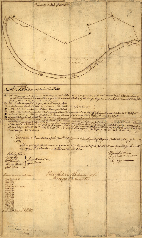
Plat of a survey of 2,314 acres of land, being the first large bottom on the east side of the Ohio River : 3 or 4 miles below the mouth, a portion of which is divided into 17 lots
This map is also available in American Revolutionary Geographies Online (ARGO), a collections portal especially built for material relating to the American Revolutionary War Era. Visit ARGO to learn more about this item and explore the historical geography of North America in the late eighteenth century.
Item Information
- Title:
- Plat of a survey of 2,314 acres of land, being the first large bottom on the east side of the Ohio River : 3 or 4 miles below the mouth, a portion of which is divided into 17 lots
- Title (alt.):
-
Plat of a survey of 2,314 acres of land, being the first large bottom on the east side of the Ohio River
George Washington ; survey of land in Ohio
- Creator:
- Crawford, William, 1732-1782
- Contributor:
- Washington, George, 1732-1799
- Name on Item:
-
W. Crawford, surv.
- Date:
-
1771
- Format:
-
Maps/Atlases
Manuscripts
- Location:
- Library of Congress Geography and Map Division
- Collection (local):
-
Library of Congress Collection
- Subjects:
-
Real property--West Virginia--Wood County--Maps--Early works to 1800
Land grants--West Virginia--Wood County--Maps--Early works to 1800
Wood County (W. Va.)--Maps, Manuscript--Early works to 1800
- Places:
-
Wood (county)
- Extent:
- 1 manuscript map 57 x 34 cm. fold. in portfolio 35 x 23 cm.
- Terms of Use:
-
No known copyright restrictions.
This work is licensed for use under a Creative Commons Attribution Non-Commercial Share Alike License (CC BY-NC-SA).

- Scale:
-
Scale ca. 1:20,000
- Language:
-
English
- Catalog Record:
-
https://lccn.loc.gov/75690212
- Notes:
-
Title from Lawrence Martin's The George Washington atlas. 1932.
Cover title: George Washington; survey of land in Ohio, a grant from the Colony of Virginia to Washington for military services ...
Manuscript, pen-and-ink.
Oriented with north toward the lower left.
Imperfect: Deteriorated along fold lines.
Annotated by George Washington: Patented in the name of George Washington.
Includes table of "River courses & distances" annotated by George Washington and "A table to explain this plat."
On verso: Survey for 2,314 acres, bottom-Ohio, made-in-1771.
Accompanied by typewritten letter of Sept. 26, 1921, signed "Warren G. Harding," to David G. Joyce, Chicago.
- Notes (citation):
-
LC Maps of North America, 1750-1789, 785
- Identifier:
-
ct000358


