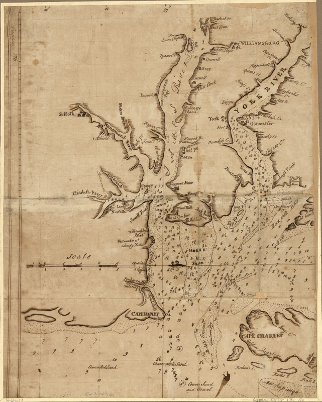
Chart showing the depth of the James and York rivers as they enter Chesapeake Bay, with towns adjacent
This map is also available in American Revolutionary Geographies Online (ARGO), a collections portal especially built for material relating to the American Revolutionary War Era. Visit ARGO to learn more about this item and explore the historical geography of North America in the late eighteenth century.
Item Information
- Title:
- Chart showing the depth of the James and York rivers as they enter Chesapeake Bay, with towns adjacent
- Date:
-
[1781?]
- Format:
-
Maps/Atlases
Manuscripts
- Location:
- Library of Congress Geography and Map Division
- Collection (local):
-
Library of Congress Collection
- Subjects:
-
Nautical charts--Chesapeake Bay (Md. and Va.)--Early works to 1800
Chesapeake Bay (Md. and Va.)--Maps, Manuscript--Early works to 1800
Virginia Peninsula (Va.)--Maps, Manuscript--Early works to 1800
York River (Va.)--Maps, Manuscript--Early works to 1800
James River (Va.)--Maps, Manuscript--Early works to 1800
- Places:
-
Chesapeake Bay
York (river)
James (river)
- Extent:
- 1 manuscript map 47 x 37 cm.
- Terms of Use:
-
No known copyright restrictions.
This work is licensed for use under a Creative Commons Attribution Non-Commercial Share Alike License (CC BY-NC-SA).

- Scale:
-
Scale ca. 1:200,000
- Language:
-
English
- Catalog Record:
-
https://lccn.loc.gov/74691683
- Notes:
-
Title from P. L. Phillips' A list of maps of America, p. 227.
Manuscript, pen-and-ink.
Oriented with north to the right.
Shows settlements, points of interest, and aids to navigation.
- Identifier:
-
ct004166


