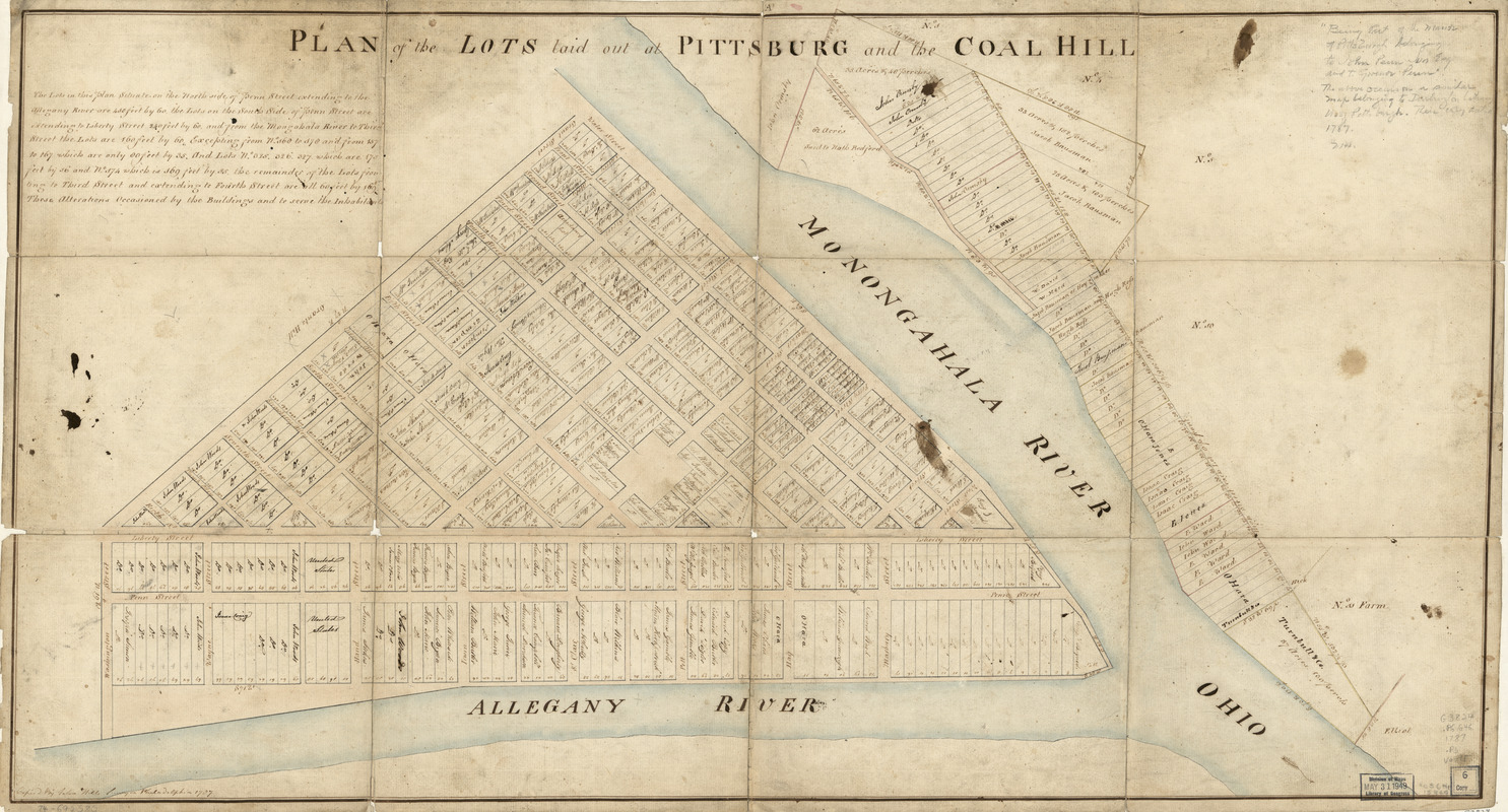
Plan of the lots laid out at Pittsburg and the Coal Hill
This map is also available in American Revolutionary Geographies Online (ARGO), a collections portal especially built for material relating to the American Revolutionary War Era. Visit ARGO to learn more about this item and explore the historical geography of North America in the late eighteenth century.
Item Information
- Title:
- Plan of the lots laid out at Pittsburg and the Coal Hill
- Creator:
- Hills, John, (Surveyor)
- Name on Item:
-
Copied by John Hills, surveyor, Philadelphia
- Date:
-
1787
- Format:
-
Maps/Atlases
Manuscripts
- Location:
- Library of Congress Geography and Map Division
- Collection (local):
-
Library of Congress Collection
- Subjects:
-
Real property--Pennsylvania--Pittsburgh--Maps--Early works to 1800
Pittsburgh (Pa.)--Maps--Early works to 1800
- Places:
-
Allegheny (county)Pittsburgh
- Extent:
- 1 manuscript map : hand color 46 x 87 cm.
- Terms of Use:
-
No known copyright restrictions.
This work is licensed for use under a Creative Commons Attribution Non-Commercial Share Alike License (CC BY-NC-SA).

- Scale:
-
Scale ca. 1:1,600
- Language:
-
English
- Catalog Record:
-
https://lccn.loc.gov/74692580
- Notes:
-
Title, on label, on verso: Plan of the lots at Pittsburg & Coal Hill and the manor.
Manuscript, pen-and-ink and watercolor.
Imperfect: Deteriorated along previous fold lines.
Watermark: J. Whatman.
Oriented with north to the bottom.
Cadastral map.
Annotated in pencil in upper right corner "Being part of the manor of Pittsburgh belonging to John Penn Jun., Esq. and to Governor Penn." The above occurs on a similar map dated 1787, belonging to Darlington Library, U. of Pittsburgh.
Includes textual information on the size of lots.
- Notes (citation):
-
LC Maps of North America, 1750-1789, 1333
- Identifier:
-
ar133300