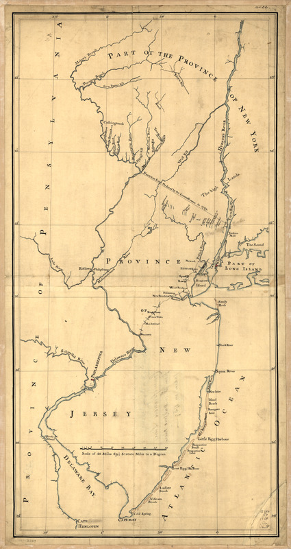
New York & New Jersey commissioners line from 41⁰ on Hudson's River taken in 1769
This map is also available in American Revolutionary Geographies Online (ARGO), a collections portal especially built for material relating to the American Revolutionary War Era. Visit ARGO to learn more about this item and explore the historical geography of North America in the late eighteenth century.
Item Information
- Title:
- New York & New Jersey commissioners line from 41⁰ on Hudson's River taken in 1769
- Date:
-
[1769?]
- Format:
-
Maps/Atlases
Manuscripts
- Location:
- Library of Congress Geography and Map Division
- Collection (local):
-
Library of Congress Collection
- Subjects:
-
New Jersey--Boundaries--New York (State)--Maps, Manuscript--Early works to 1800
New York (State)--Boundaries--New Jersey--Maps, Manuscript--Early works to 1800
New Jersey--Maps, Manuscript--Early works to 1800
- Places:
-
New York
New Jersey
- Extent:
- 1 manuscript map : hand color, 64 x 32 cm.
- Terms of Use:
-
No known copyright restrictions.
This work is licensed for use under a Creative Commons Attribution Non-Commercial Share Alike License (CC BY-NC-SA).

- Scale:
-
Scale ca. 1:600,000
- Language:
-
English
- Catalog Record:
-
https://lccn.loc.gov/gm71002209
- Notes:
-
Title from verso.
At head of title, in a different hand: New York & New Jersey.
Manuscript, pen-and-ink and watercolor.
Shows "Province of New Jersey," "Part of the province of New York," part of the "Province of Pensylvania," and the "Partition line ordered by the commissioners in 1769."
"No. 26."
- Notes (citation):
-
LC Maps of North America, 1750-1789, 1243
- Identifier:
-
ar124300

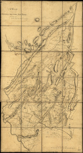
![Three maps [i.e. map on 3 sheets] of northern New Jersey, with reference to the boundary between New York and New Jersey](https://bpldcassets.blob.core.windows.net/derivatives/images/commonwealth:q524nk04q/image_thumbnail_300.jpg)