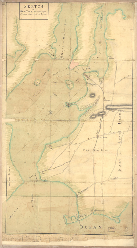
Sketch of New York, narrows & part of Long Island with the roads
This map is also available in American Revolutionary Geographies Online (ARGO), a collections portal especially built for material relating to the American Revolutionary War Era. Visit ARGO to learn more about this item and explore the historical geography of North America in the late eighteenth century.
Item Information
- Title:
- Sketch of New York, narrows & part of Long Island with the roads
- Date:
-
[1776?]
- Format:
-
Maps/Atlases
Manuscripts
- Location:
- Library of Congress Geography and Map Division
- Collection (local):
-
Library of Congress Collection
- Subjects:
-
New York Region--Maps, Manuscript--Early works to 1800
Harbors--New York (State)--New York--Maps--Early works to 1800
Roads--New York (State)--Kings County--Maps--Early works to 1800
- Places:
-
New York
- Extent:
- 1 manuscript map : hand color, 89 x 49 cm.
- Terms of Use:
-
No known copyright restrictions.
This work is licensed for use under a Creative Commons Attribution Non-Commercial Share Alike License (CC BY-NC-SA).

- Scale:
-
Scale ca. 1:23,000
- Language:
-
English
- Catalog Record:
-
https://lccn.loc.gov/73691874
- Notes:
-
Manuscript, pen-and-ink and watercolor.
Has watermarks.
Relief shown by hachures. Soundings in fathoms.
Shows distances.
In margin, upper left corner: No. 18.
- Notes (citation):
-
LC Maps of North America, 1750-1789, 1227
- Identifier:
-
ar122700z

![Plan of Governor's, Kennedy's, and Brown's Islan[ds] and Red Hook together with part of the Bay and soundings](https://bpldcassets.blob.core.windows.net/derivatives/images/commonwealth:q524nj614/image_thumbnail_300.jpg)

