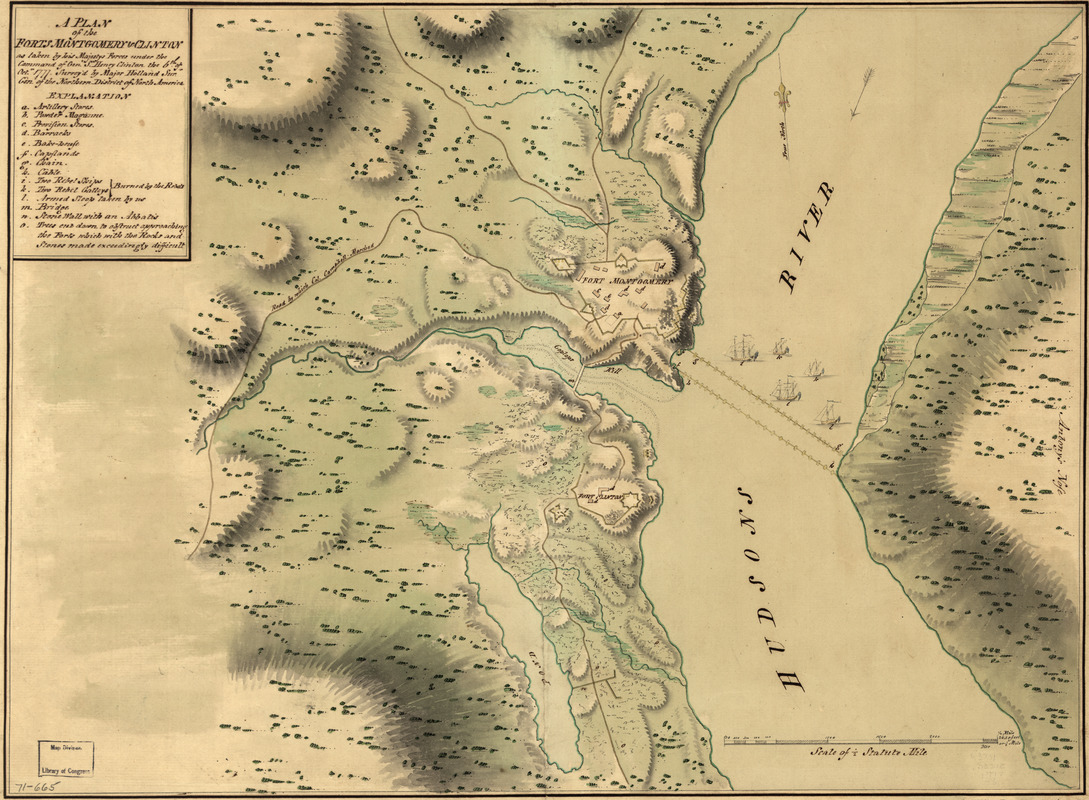
A plan of the Forts Montgomery & Clinton : as taken by His Majesty's forces under the command of Genl. Sr. Henry Clinton the 6th. of Octr. 1777
This map is also available in American Revolutionary Geographies Online (ARGO), a collections portal especially built for material relating to the American Revolutionary War Era. Visit ARGO to learn more about this item and explore the historical geography of North America in the late eighteenth century.
Item Information
- Title:
- A plan of the Forts Montgomery & Clinton : as taken by His Majesty's forces under the command of Genl. Sr. Henry Clinton the 6th. of Octr. 1777
- Creator:
- Holland, Samuel, 1728-1801
- Name on Item:
-
Survey'd by Major Holland, surr. genl. of the Northern District of North America
- Date:
-
[1777]
- Format:
-
Maps/Atlases
Manuscripts
- Location:
- Library of Congress Geography and Map Division
- Collection (local):
-
Library of Congress Collection
- Subjects:
-
Manuscript maps
Fort Clinton, N.Y. (Rockland Co.)--Maps--Early works to 1800
Fort Montgomery, N.Y--Maps--Early works to 1800
- Places:
-
Orange (county)Fort Montgomery
Rockland (county)Fort Clinton
- Extent:
- 1 manuscript map : hand color, 39 x 53 cm.
- Terms of Use:
-
No known copyright restrictions.
This work is licensed for use under a Creative Commons Attribution Non-Commercial Share Alike License (CC BY-NC-SA).

- Scale:
-
Scale ca. 1:18,000
- Language:
-
English
- Catalog Record:
-
https://lccn.loc.gov/gm71000665
- Notes:
-
Has watermarks.
Relief shown by hachures.
Pictorial map.
Includes index entitled "Explanation."
Scale not ca. 1:6,000 as depicted by bar scale.
- Notes (date):
-
This date is inferred.
- Notes (citation):
-
LC Maps of North America, 1750-1789, 1189
- Identifier:
-
ar118900


![Armstrong C[ount]y](https://bpldcassets.blob.core.windows.net/derivatives/images/commonwealth:q524ng353/image_thumbnail_300.jpg)

