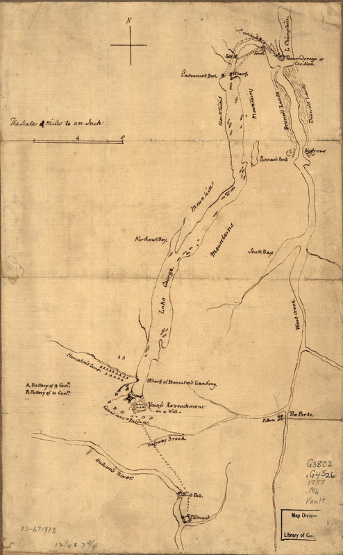
Plan of the attack on Fort William Henry and Ticonderoga : showing the road from Fort Edward, Montcalm's camp and wharf of landing, &c
This map is also available in American Revolutionary Geographies Online (ARGO), a collections portal especially built for material relating to the American Revolutionary War Era. Visit ARGO to learn more about this item and explore the historical geography of North America in the late eighteenth century.
Item Information
- Title:
- Plan of the attack on Fort William Henry and Ticonderoga : showing the road from Fort Edward, Montcalm's camp and wharf of landing, &c
- Title (alt.):
-
Fort William Henry and Ticonderoga
Ticonderoga
- Creator:
- Montrésor, James Gabriel, 1702-1776
- Date:
-
[1757?]
- Format:
-
Maps/Atlases
Manuscripts
- Location:
- Library of Congress Geography and Map Division
- Collection (local):
-
Library of Congress Collection
- Subjects:
-
George, Lake (N.Y. : Lake) Region--History--Maps--Early works to 1800
Manuscript maps--Early works to 1800
- Places:
-
George, Lake
- Extent:
- 1 manuscript map; on sheet 32 x 20 cm.
- Terms of Use:
-
No known copyright restrictions.
This work is licensed for use under a Creative Commons Attribution Non-Commercial Share Alike License (CC BY-NC-SA).

- Scale:
-
Scale 1:253,440
- Language:
-
English
- Catalog Record:
-
https://lccn.loc.gov/73691813
- Notes:
-
Title from Philip Lee Phillips' A list of maps of America, p. 852.
Manuscript, pen-and-ink.
Has watermark.
- Identifier:
-
ar302900


