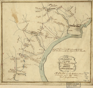
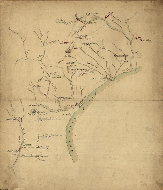
Operations of the British army, from the 25th August to 26th Sept. 1777
This map is also available in American Revolutionary Geographies Online (ARGO), a collections portal especially built for material relating to the American Revolutionary War Era. Visit ARGO to learn more about this item and explore the historical geography of North America in the late eighteenth century.
Item Information
- Title:
- Operations of the British army, from the 25th August to 26th Sept. 1777
- Creator:
- Montrésor, John, 1736-1799
- Date:
-
[1777?]
- Format:
-
Maps/Atlases
Manuscripts
- Location:
- Library of Congress Geography and Map Division
- Collection (local):
-
Library of Congress Collection
- Subjects:
-
Middle Atlantic States--History--Revolution, 1775-1783--Campaigns--Maps, Manuscript--Early works to 1800
- Places:
-
Middle Atlantic (area)
- Extent:
- 1 manuscript map : hand color on sheet 53 x 45 cm.
- Terms of Use:
-
No known copyright restrictions.
This work is licensed for use under a Creative Commons Attribution Non-Commercial Share Alike License (CC BY-NC-SA).

- Scale:
-
Scale ca. 1:100,000
- Language:
-
English
- Catalog Record:
-
https://lccn.loc.gov/gm71000921
- Notes:
-
Title from Peter Force's catalog of manuscript maps.
Alternate title from Philip Lee Phillips' A list of maps of America, p. 699: Map showing the march of the British upon Philadelphia.
Manuscript, pen-and-ink and watercolor.
Has watermark.
Relief shown by hachures.
"No. 20."
Stamped on verso: Montresor.
- Notes (citation):
-
LC Maps of North America, 1750-1789, 1060
- Identifier:
-
ar106000