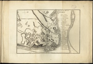
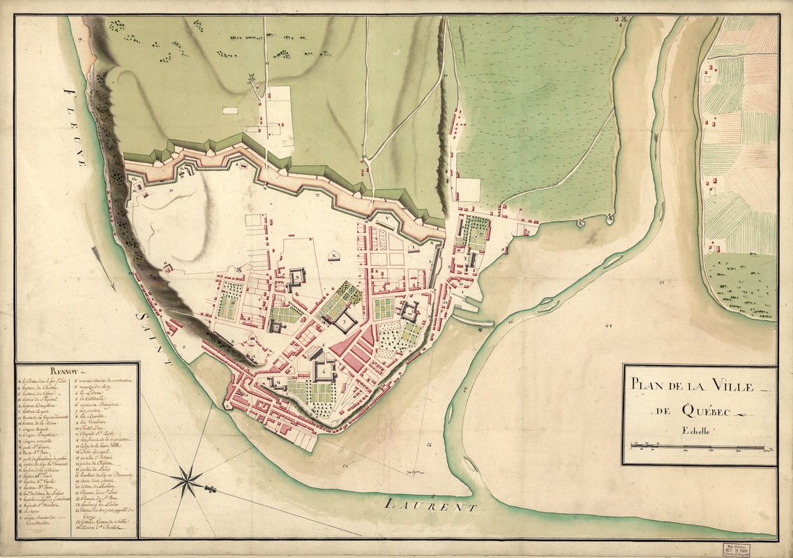
Plan de la ville de Québec
This map is also available in American Revolutionary Geographies Online (ARGO), a collections portal especially built for material relating to the American Revolutionary War Era. Visit ARGO to learn more about this item and explore the historical geography of North America in the late eighteenth century.
Item Information
- Title:
- Plan de la ville de Québec
- Date:
-
[1750?]
- Format:
-
Maps/Atlases
Manuscripts
- Location:
- Library of Congress Geography and Map Division
- Collection (local):
-
Library of Congress Collection
- Subjects:
-
Québec (Québec)--Maps, Manuscript--Early works to 1800
Fortification--Québec (Province)--Québec--Maps--Early works to 1800
- Places:
-
CanadaQuébec
- Extent:
- 1 map : col. ; 53 x 76 cm.
- Terms of Use:
-
No known copyright restrictions.
This work is licensed for use under a Creative Commons Attribution Non-Commercial Share Alike License (CC BY-NC-SA).

- Scale:
-
Scale ca. 1:3,500
- Language:
-
French
- Catalog Record:
-
https://lccn.loc.gov/74694519
- Notes:
-
Manuscript, pen-and-ink and watercolor.
Relief shown by shading.
Oriented with north toward the lower right.
Indexed for points of interest.
- Notes (citation):
-
LC Maps of North America, 1750-1789, 594
- Identifier:
-
ar059400

![Plan of Quebec, the capital of Canada in North America, with the bason and part of the adjacent contry [sic] shewing the principal encampments and works of the British Army commanded by Maior General Wolfe and those of the French Army commanded by Lieut. General, the Marquis of Mont Calm during the siege of that place in 1759 [overlay down]](https://bpldcassets.blob.core.windows.net/derivatives/images/commonwealth:q524nd83b/image_thumbnail_300.jpg)
![Plan of Quebec, the capital of Canada in North America, with the bason and part of the adjacent contry [sic] shewing the principal encampments and works of the British Army commanded by Maior General Wolfe and those of the French Army commanded by Lieut. General, the Marquis of Mont Calm during the siege of that place in 1759 [overlay up]](https://bpldcassets.blob.core.windows.net/derivatives/images/commonwealth:q524nd81s/image_thumbnail_300.jpg)