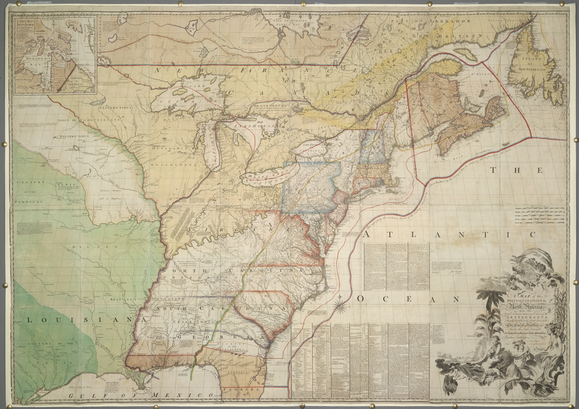
A MAP of the BRITISH COLONIES in North America : WITH THE Roads, Distances, Limits, and Extent of the SETTLEMENTS, Humbly Inscribed to the Right Honourable The Early of Halifax, and the other Right Honourable The Lords Commissioners for Trade & Plantations
This map is also available in American Revolutionary Geographies Online (ARGO), a collections portal especially built for material relating to the American Revolutionary War Era. Visit ARGO to learn more about this item and explore the historical geography of North America in the late eighteenth century.
Item Information
- Title:
- A MAP of the BRITISH COLONIES in North America : WITH THE Roads, Distances, Limits, and Extent of the SETTLEMENTS, Humbly Inscribed to the Right Honourable The Early of Halifax, and the other Right Honourable The Lords Commissioners for Trade & Plantations
- Cartographer:
- Mitchell, John, 1711-1768
- Former owner:
- George, III, King of Great Britain, 1738-1820
- Donor:
- George, IV, King of Great Britain, 1762-1830
- Annotator:
- Oswald, Richard, 1705-1784
- Printmaker:
- Kitchin, Thomas, 1718-1784
- Publisher:
- Jefferys, Thomas, -1771
- Publisher:
- Faden, William, 1749-1836
- Publisher:
- Jefferys & Faden (London, England)
- Name on Item:
-
By their Lordships Most Obliged and very humble Servant Jn.o Mitchell.
- Date:
-
1775
- Format:
-
Maps/Atlases
- Location:
- British Library
- Collection (local):
-
British Library Collection
- Subjects:
-
North America--Maps--Early works to 1800
Great Britain--Colonies--North America--Maps--Early works to 1800
United States--Boundaries--Maps--Early works to 1800
United States--History--Revolution, 1775-1783--Maps--Early works to 1800
- Places:
-
North America (area)
- Extent:
- 1 map : hand-colored ; 136 x 193 cm
- Terms of Use:
-
No known copyright restrictions.
This work is licensed for use under a Creative Commons Attribution Non-Commercial Share Alike License (CC BY-NC-SA).

- Publisher:
-
London :
Printed for Jefferys & Faden
- Scale:
-
Scale approximately 1:2,000,000
- Language:
-
English
- Catalog Record:
-
http://explore.bl.uk/BLVU1:LSCOP-ALL:BLL01004993958
- Notes:
-
Relief shown pictorially.
This copy also known as 'the red-lined map' or the 'King George map'.
The manuscript red line added in ink by Richard Oswald, secretary to the British delegation at the Treaty of Paris (1782-83) where negotiations to end the American Revolutionary War took place, is used to identify the British interpretation of the boundary of the new United States. Added in about 1782.
"After the treaty was concluded, Oswald gave this map to King George III; it is now in the British Library. The king himself labeled the red line in ten places as "Boundary as described by Mr. Oswald." For this reason, this map is usually referred to as the "red line" map. This map is thus a statement of the British vision of North American territories." - Edney.
Manuscript annotations on the map include; "Line expressing the exclusive Right of the Fishery reserved to Great Britain by this Treat of Utrecht, extending 30 Leagues from the Land", "Boundary Line between the English and French Territories according to the French constructed at the Treaty of Utrecht", "Boundary between the Lands granted to the Hudson's Bay Company and the Province of Quebec", "NB The Treaty of Utrecht reserves to France Cape Breton and the other Islands in the Gulph of St Lawrence".
John Jay, from the American delegation negotiating for the Treaty of Paris, also used an example of the Mitchell map. His copy of the Mitchell map is now held by the New York Historical Society.
The Osher Map Library at the University of Southern Maine has an example of the Mitchell map with annotations copied from the "King George Map" (copied from this British Libray example) in 1898. The National Archives in the United States hold another example of the Mitchell map with annotations copied from the "King George Map" by B.F. Stevens in 1897 (National Archives Identifier: 2450020) - Edney.
First drawn in 1750, the map was updated and published for the first time in February 1755. The title of earlier states differs from the title of this final edition published in about 1775. See Maps K.Top.118.49.a. (state 3) and Maps K.Top.118.49.c. (state 1) for other states of the map in the King's Topographical Collection.
State 7 of the map - Pritchard and Taliaferro. With manuscript additions.
Title in a decorative cartouche at lower right illustrated with indigenous flora and fauna, and Native American figures. Surmounted by a Union Jack flag.
"Tho: Kitchin Sculp." is printed beneath the title.
Scales given above the title - "Miles or Minutes of Latitude Marked M1", "English Miles 69 1/2 to a Degree Marked M1s", "English and French Sea-Leagues 20 to a Degree", "Common French Leagues 25 to a Degree" and "Dutch Miles 15 to a Degree".
A short key includes "Indian Towns & Forts", "Roads with their Distances", "Falls in Rivers" and "Indian Villages deserted".
Inset map at upper left shows "A NEW MAP of HUDSON'S BAY and LABRADOR from the late SURVEYS of those COASTS" (scale approximately 1:20,275,000).
Titled "Another Copy of ditto, in a Case, 4to" where ditto is "A Map of the British and French Dominions in North America, with the roads, distances, limits, and extent of the Settlements: by John Mitchell, 1755. Eight sheets" in the Catalogue of Maps, Prints, Drawings, etc., forming the geographical and topographical collection attached to the Library of his late Majesty King George the third, etc., London, 1829.
Copy at Maps K.Top.118.49.b. Exhibited: 'Maps: Finding Our Place in the World', Walters Art Gallery, Baltimore, 14 March 2008 - 8 June 2008. Uk
Copy at Maps K.Top.118.49.b. Exhibited: 'Maps: Finding Our Place in the World', Field Museum, Chicago, 2 November 2007 - 27 January 2008. Uk
Copy at Maps K.Top.118.49.b. Exhibited: 'Lie of the Land : the Secret Life of Maps', British Library, 27 July 2001 to 7 April 2002. Display label text from 'Lie of the Land: the Secret Life of Maps', British Library, 2001-2002: "The 'Red-lined' map, 1782 This map by John Mitchell, originally published in 1755, was still considered the most authoritative map of North America in 1782. This copy became known as the 'Red-Lined' map when it was used during the negotations of the Treaty of Paris which recognised the independence of the United States of America at the end of the American War of Independence (1776-83). The red lines were added by Richard Oswald, the secretary to the British delegation in Paris and a good friend of American patriot Benjamin Franklin, for the private use of his British colleagues. The final treaty line of 1783 was much more favourable to the British. Fear of revealing the earlier line and of being compelled to surrender large tracts of Canadian land to the USA led successive British governments to forbid unauthorised access to the map until 1896. It was still being used as evidence in internal boundary disputes in both the United States and Canada as late as 1932. The map found its way into King George III's private collection. John Mitchell, A map of the British and French Dominions in North America.. Revised edition. London, 1775, with manuscript additions, [1782]. Maps K.Top.118.49.b". Uk
Exhibited: "The American War of Independence, 1775-84: a commemorative exhibition organized by the Map Library and the Department of Manuscripts of the British Library Reference Division", The British Library, London, 4 July 1975 – 11 November 1975. Uk
Copy at Maps K.Top. 118.49.b. Part of King George III's Topographical Collection. Donated to the nation by George IV. Uk
Copy at Maps K.Top. 118.49.b. printed from 8 plates on 8 sheets, dissected into 32 sheet, laid on linen. Trimmed close with minor loss of detail to printed edge. Case referred to in 1829 catalogue no longer present. Stored as a roll. Manuscript addition in pencil to verso "Was 118.d.26.". Stamp of British Museum in title (not oval stamp in yellow). Uk
Copy at Maps K.Top.118.49.b. digitised 2014 The British Library King's Topographical Collection Digitisation Project pda Uk


![[A map of the east coast of America from Newfoundland to the Bay of Honduras]](https://bpldcassets.blob.core.windows.net/derivatives/images/commonwealth:hx11z584h/image_thumbnail_300.jpg)

