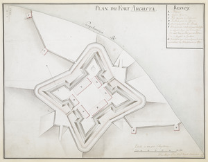
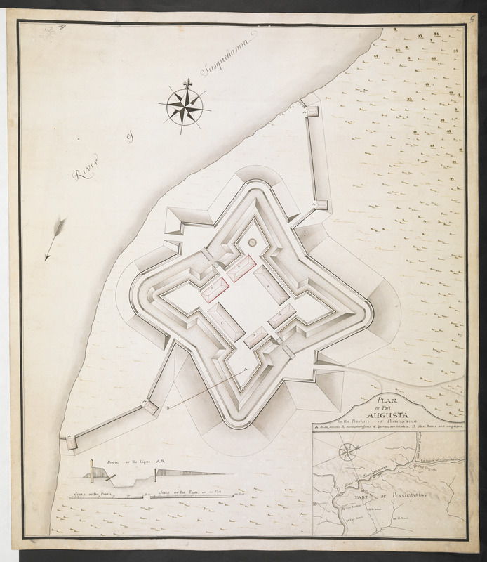
PLAN OF Fort AUGUSTA in the Province OF Pansilvania
This map is also available in American Revolutionary Geographies Online (ARGO), a collections portal especially built for material relating to the American Revolutionary War Era. Visit ARGO to learn more about this item and explore the historical geography of North America in the late eighteenth century.
Item Information
- Title:
- PLAN OF Fort AUGUSTA in the Province OF Pansilvania
- Description:
-
Map of Fort Augusta that was located on the banks of River Susquehanna in present-day Sunbury, Penssylvania.
- Former owner:
- Royal United Services Institute for Defence and Security Studies
- Date:
-
[ca. 1760]
- Format:
-
Maps/Atlases
- Location:
- British Library
- Collection (local):
-
British Library Collection
- Subjects:
-
Fortification--Susquehanna River--Maps, Manuscript--Early works to 1800
Military art and science--Susquehanna River--Maps, Manuscript--Early works to 1800
Fort Augusta (Pa.)--Maps, Manuscript--Early works to 1800
Susquehanna River--Maps, Manuscript--Early works to 1800
- Places:
-
Susquehanna River
Northumberland (county)Sunbury
- Extent:
- 1 map : manuscript pen and ink ; 51 x 45 cm
- Terms of Use:
-
No known copyright restrictions.
This work is licensed for use under a Creative Commons Attribution Non-Commercial Share Alike License (CC BY-NC-SA).

- Publisher:
-
[Place of production not identified] :
[Producer not identified]
- Scale:
-
Scale approximately 1:360
- Language:
-
English
- Catalog Record:
-
http://searcharchives.bl.uk/IAMS_VU2:IAMS040-001999746
- Notes:
-
Date attributed on stylistic grounds and based on other forts shown on inset map (Fort Harris, Fort Halifax and Fort Augusta are shown within the wider environs of the Susquehanna River).
Shows title at lower right above inset map of wider environs. Title also incorporates lettered key (A-D).
Shows a profile through the fort at lower left (marked A-B on the map).
Shows scale bars lat lower left"Scale of the Profil" and "Scale of the Plan".
A decotative compass rose and arro indicate north on the map and the direction of flow of the River Susquehanna.
Copy at Add Ms 57,714.5. Bound in R.U.S.I. Vol LXXIX. Shows manuscript addition of "5" in pencil at upper right. Shows "A 30/23" in pencil at upper left. Laid on archival tissue. Green circular label to verso shows "2". White label to verso shows "DRAWER 30 SECTION 1". Blue label to verso shows "A 30/23". Paper watermark shows a "IVILLIADARY".
- Notes (date):
-
9999