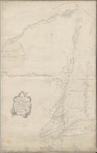
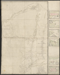
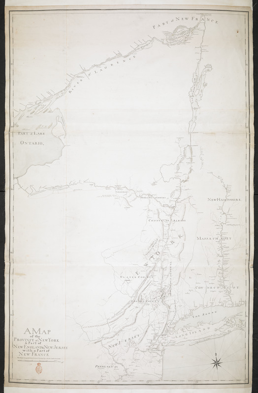
A MAP of the PROVINCE of NEW YORK & Part of NEW ENGLAND & NEW JERSEY with Part of NEW FRANCE the whole Compsed from Actual Surveys by a Scale 8 miles to a Inch
This map is also available in American Revolutionary Geographies Online (ARGO), a collections portal especially built for material relating to the American Revolutionary War Era. Visit ARGO to learn more about this item and explore the historical geography of North America in the late eighteenth century.
Item Information
- Title:
- A MAP of the PROVINCE of NEW YORK & Part of NEW ENGLAND & NEW JERSEY with Part of NEW FRANCE the whole Compsed from Actual Surveys by a Scale 8 miles to a Inch
- Cartographer:
- Pfister, Francis, 1740-1777
- Former owner:
- Amherst, Jeffery Amherst, Baron, 1717-1797
- Former owner:
- Royal United Services Institute for Defence and Security Studies
- Name on Item:
-
Franc. Pfister cop.t.
- Date:
-
[ca. 1759]
- Format:
-
Maps/Atlases
- Location:
- British Library
- Collection (local):
-
British Library Collection
- Subjects:
-
United States--History--French and Indian War, 1754-1763--Maps, Manuscript--Early works to 1800
New York (State)--Maps, Manuscript--Early works to 1800
- Places:
-
New York
- Extent:
- 1 map on 4 sheets : joined, manuscript pen and ink in black and red with blue wash ; 127 x 80 cm
- Terms of Use:
-
No known copyright restrictions.
This work is licensed for use under a Creative Commons Attribution Non-Commercial Share Alike License (CC BY-NC-SA).

- Publisher:
-
[Place of production not identified] :
Franc. Pfister cop.t.,
- Scale:
-
Scale approximately 1:506,880
- Language:
-
English
- Catalog Record:
-
http://searcharchives.bl.uk/IAMS_VU2:IAMS040-001999745
- Notes:
-
Date suggested from comparison with other Pfister maps showing similar detail at a reduced size - see Maps K.Top.121.1. and Maps K.Top.121.2.
Relief is shown pictorially.
Shows roads.
Shows forts.
Shows title at lower left. Does Pfister's statement of reponsibility imply this map is copied from another?
Shows geographical detail focusing on major rivers and their immediate environs, and areas of military importance.
Copy at Add Ms 57,713.1. In a solander box, R.U.S.I. Vol LXXV and LXXVIII. Comprises 4 sheets, joined and laid on linen. Shows red stamp of R.U.S.I. at lower left. Green circular label to verso shows "15". White label to verso shows "DRAWER 29 SECTION 2". Blue label to verso shows "A 29/15". Shows "C 56" in pencil to verso. Pressmark stamped in black ink to verso.
- Notes (date):
-
9999

![[A colored map of the route between Albany and Oswego; drawn about 1756, on a scale of 2 miles to an inch]](https://bpldcassets.blob.core.windows.net/derivatives/images/commonwealth:hx11z3223/image_thumbnail_300.jpg)