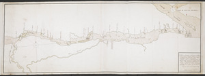
[Sketch map of an unidentified fort]
![[Sketch map of an unidentified fort]](https://bpldcassets.blob.core.windows.net/derivatives/images/commonwealth:hx11z101x/image_access_800.jpg)
This map is also available in American Revolutionary Geographies Online (ARGO), a collections portal especially built for material relating to the American Revolutionary War Era. Visit ARGO to learn more about this item and explore the historical geography of North America in the late eighteenth century.
Item Information
- Title:
- [Sketch map of an unidentified fort]
- Cartographer:
- Laforce, René-Hippolyte, 1728-1802
- Former owner:
- Amherst, Jeffery Amherst, Baron, 1717-1797
- Former owner:
- Royal United Services Institute for Defence and Security Studies
- Date:
-
[1760]
- Format:
-
Maps/Atlases
- Location:
- British Library
- Collection (local):
-
British Library Collection
- Subjects:
-
Fortification--Saint Lawrence River--Maps, Manuscript--Early works to 1800
Military art and science--Saint Lawrence River--Maps, Manuscript--Early works to 1800
Saint Lawrence River--Maps, Manuscript--Early works to 1800
- Places:
-
Saint Lawrence River
- Extent:
- 1 map : manuscript pen and ink with pencil ; 20 x 33 cm
- Terms of Use:
-
No known copyright restrictions.
This work is licensed for use under a Creative Commons Attribution Non-Commercial Share Alike License (CC BY-NC-SA).

- Publisher:
-
[Place of production not identified] :
[René-Hippolyte Laforce]
- Scale:
-
Scale not given
- Language:
-
French
- Catalog Record:
-
http://searcharchives.bl.uk/IAMS_VU2:IAMS040-001999737
- Notes:
-
Location depicted not identified - shows a fortified location on a river or lake (also unnamed). If north is oriented to the bottom of the map the fortified location is shown on the wrong side of the river to be Fort de la Présentation. However, Fort de la Présentation is one of the few locations identified (along with Fort Lévis, an island location and so not depicted on this map) on Laforce's map of the larger area (see Add Ms 57,707.7.). Could it be Fort Frontenac (now within Kingston, Ontario)? Could it be Fort Chouguen (later Fort Oswego)?
Attribution to Laforce from previous British Library cataloguing (see citation).
Date from depiction of fort "La presentation" (see Add Ms 57,707.7.) which was renamed by the British in 1760.
Compare also Add Ms 57,707.6. and Add Ms 57,707.7., and Add Ms 57,707.9. and Add Ms 57,707.10.
Copy at Add Ms 57,707.5. Bound in R.U.S.I. Vol LXXII. Shows manuscript addition of "5" in pencil at upper right. Shows "A 20" in pencil at lower right and "A 28/48A" at lower left. Laid on archival tissue. Green circular label to verso showing "23b". Manuscript addition to verso in pencil shows "Drawer 28 Sec 2". Blue label to verso shows "A 28/48A". Paper watermarks shows a coat of arms.
- Notes (date):
-
9999
This date is inferred.

![[An unfinished chart of the Saint Lawrence River from Perrot Island to the Island of Orleans]](https://bpldcassets.blob.core.windows.net/derivatives/images/commonwealth:hx11z0836/image_thumbnail_300.jpg)
![[Map showing the location of Fort de la Presentation]](https://bpldcassets.blob.core.windows.net/derivatives/images/commonwealth:hx11z0993/image_thumbnail_300.jpg)