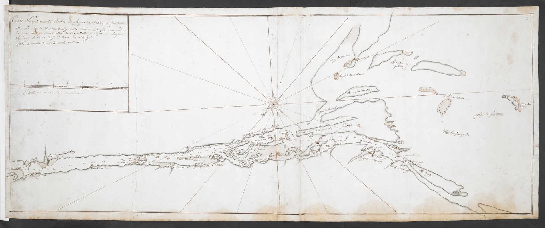
Carte Nouvellement Releve de La presantation a Frontenac : Nee Les Soude & moulliage cett Rivier Est for courant depuis Les premier illes de Layallette jusqu au Laquel ille may Bonne aus Et bon moulliage faitte a montrialle ce 24 octobre 1758
This map is also available in American Revolutionary Geographies Online (ARGO), a collections portal especially built for material relating to the American Revolutionary War Era. Visit ARGO to learn more about this item and explore the historical geography of North America in the late eighteenth century.
Item Information
- Title:
- Carte Nouvellement Releve de La presantation a Frontenac : Nee Les Soude & moulliage cett Rivier Est for courant depuis Les premier illes de Layallette jusqu au Laquel ille may Bonne aus Et bon moulliage faitte a montrialle ce 24 octobre 1758
- Cartographer:
- La Broquerie, Pierre Boucher de
- Former owner:
- Royal United Services Institute for Defence and Security Studies
- Date:
-
1758
- Format:
-
Maps/Atlases
- Location:
- British Library
- Collection (local):
-
British Library Collection
- Subjects:
-
Rivers--Saint Lawrence River--Maps, Manuscript--Early works to 1800
Fortification--Saint Lawrence River--Maps, Manuscript--Early works to 1800
Military art and science--Saint Lawrence River--Maps, Manuscript--Early works to 1800
Saint Lawrence River--Maps, Manuscript--Early works to 1800
- Places:
-
Saint Lawrence River
- Extent:
- 1 map on 2 sheets : joined, manuscript pen and ink with watercolour , over pencil ; 36 x 96 cm
- Terms of Use:
-
No known copyright restrictions.
This work is licensed for use under a Creative Commons Attribution Non-Commercial Share Alike License (CC BY-NC-SA).

- Publisher:
-
A montrialle :
[Pierre Boucher de La Broquerie]
- Scale:
-
Scale approximately 1:218,740
- Language:
-
French
- Catalog Record:
-
http://searcharchives.bl.uk/IAMS_VU2:IAMS040-001999737
- Notes:
-
Shows title at upper left including a scale bar, "Eschelle de huit Lieu marine".
Oriented with north to the bottom of the map, indicated by a decorative compass rose.
Shows "Fort La Presentation" and "Fort Frontenac". Also shows "Fort Villier" (?) on an island location in Lake Ontario.
Compare Maps K.Top.121.14. for a map signed by La Broquerie.
Copy at Add Ms 57,707.3. Bound in R.U.S.I. Vol LXXII. Comprises 2 sheets joined. Shows manuscript addition of "3" in pencil at upper right and "No3 18" in the margin at upper right. Laid on archival tissue. Green circular label to verso showing "33". White label to verso showing "DRAWER 28 SECTION 2". Manuscript additions to verso in pencil show "A 45", "8", A 28/??", "18" "9" and "3".
- Notes (date):
-
9999

![[An unfinished chart of the Saint Lawrence River from Perrot Island to the Island of Orleans]](https://bpldcassets.blob.core.windows.net/derivatives/images/commonwealth:hx11z0836/image_thumbnail_300.jpg)
![[Sketch map of an unidentified fort]](https://bpldcassets.blob.core.windows.net/derivatives/images/commonwealth:hx11z101x/image_thumbnail_300.jpg)
![[Map showing the location of Fort de la Presentation]](https://bpldcassets.blob.core.windows.net/derivatives/images/commonwealth:hx11z0993/image_thumbnail_300.jpg)