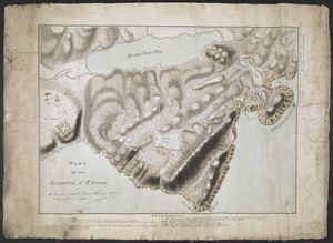
[Six sectional drawings of the Harbour of Saint John, Newfoundland]
![[Six sectional drawings of the Harbour of Saint John, Newfoundland]](https://bpldcassets.blob.core.windows.net/derivatives/images/commonwealth:6108vv37h/image_access_800.jpg)
This map is also available in American Revolutionary Geographies Online (ARGO), a collections portal especially built for material relating to the American Revolutionary War Era. Visit ARGO to learn more about this item and explore the historical geography of North America in the late eighteenth century.
Item Information
- Title:
- [Six sectional drawings of the Harbour of Saint John, Newfoundland]
- Former owner:
- Skinner, William, 1700-1780
- Former owner:
- Skinner, Monier
- Date:
-
[1775–1803]
- Format:
-
Maps/Atlases
- Location:
- British Library
- Collection (local):
-
British Library Collection
- Subjects:
-
Military art and science--Newfoundland and Labrador--St. John's--Maps, Manuscript--Early works to 1800
Fortification--Newfoundland and Labrador--St. John's--Maps, Manuscript--Early works to 1800
Harbors--Newfoundland and Labrador--St. John's--Maps, Manuscript--Early works to 1800
St. John's (N.L.)--Maps, Manuscript--Early works to 1800
- Places:
-
CanadaSaint John's
- Extent:
- 6 maps on 1 sheet : manuscript pen and ink with watercolour ; sheet 60 x 96 cm
- Terms of Use:
-
No known copyright restrictions.
This work is licensed for use under a Creative Commons Attribution Non-Commercial Share Alike License (CC BY-NC-SA).

- Publisher:
-
[Saint John] :
[producer not identified]
- Scale:
-
Scale not given
- Language:
-
English
- Catalog Record:
-
http://searcharchives.bl.uk/IAMS_VU2:IAMS040-002027386
- Notes:
-
Date from depiction of Fort Townshend (built 1775) and Thomas Skinner's return to England in 1803. Thomas Skinner's name (signature?) is given in pencil at lower right.
Six sectional profiles of the harbour of Saint John, Newfoundland: "Section No 1 From the Ocean over the Ridge of Mountains on the Nort side of the Harbour, thence over the Eminence on which Wallace's Battery is erected, and continued thro' the old Fort to the Letter F Taken upon the line A, B, C, D, E, F", "section No 1 Continued from the letter F, thro' Fort Townshend on the line F, G, H, I", "Section No 2 from the top of the South Ridge across the Narrows or Entrance of the Harbour thence over the North Ridge down to Cuckolds cove upon the line N, R, ,S T, C, U, W, X, Y, Z", "Section No 3 From the top of the South Ridge across the Harbour thence thro' Fort Townshend on the line K, I, G, L, M, N" "Section No 4 Taken from high Water mark in the Narrows over the Hill that looks into Chain Rock Battery and continued over Wallace's hill till it joins the Section No 2 at W taken on the line 5, D, 1, 2, W" and "Section No 5 Taken from the Ocean over the South end of the North Ridge and thence over the Hill above Chain Roch, down to high water mark on the line 4, T, 3".
Copy at Add Ms 33,231.II.7. A roll. Laid on linen. Manuscript annotation at centre in black ink, "Handed over to Lieut. Monier Skinner R. Eng.r by his father in 1872" and initialled (by Monier Skinner?). Red stamp of British Museum at lower right. Pressmark stamped to verso and repeated in pencil.
- Notes (date):
-
9999
This date is inferred.

![[Entrance to the Harbour of S.t Johns Newfoundland]](https://bpldcassets.blob.core.windows.net/derivatives/images/commonwealth:6108vv35z/image_thumbnail_300.jpg)
![[Map showing Saint John's Harbour and a proposed fort]](https://bpldcassets.blob.core.windows.net/derivatives/images/commonwealth:6108vw12v/image_thumbnail_300.jpg)
![[Map showing Saint John's Harbour with Fort William and Fort Townshend]](https://bpldcassets.blob.core.windows.net/derivatives/images/commonwealth:6108vv278/image_thumbnail_300.jpg)