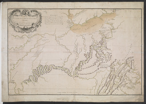
[Map of Fort Detroit and environs]
![[Map of Fort Detroit and environs]](https://bpldcassets.blob.core.windows.net/derivatives/images/commonwealth:hx11xz63b/image_access_800.jpg)
This map is also available in American Revolutionary Geographies Online (ARGO), a collections portal especially built for material relating to the American Revolutionary War Era. Visit ARGO to learn more about this item and explore the historical geography of North America in the late eighteenth century.
Item Information
- Title:
- [Map of Fort Detroit and environs]
- Former owner:
- Haldimand, Frederick, Sir, 1718-1791
- Date:
-
[1761–1763]
- Format:
-
Maps/Atlases
- Location:
- British Library
- Collection (local):
-
British Library Collection
- Subjects:
-
Fortification--Erie, Lake--Maps, Manuscript--Early works to 1800
Military art and science--Erie, Lake--Maps, Manuscript--Early works to 1800
Fort Detroit (Detroit, Mich.)--Maps, Manuscript--Early works to 1800
Sandusky Bay (Ohio)--Maps, Manuscript--Early works to 1800
Erie, Lake--Maps, Manuscript--Early works to 1800
- Places:
-
Sandusky Bay
Wayne (county)Detroit
Erie, Lake
- Extent:
- 1 map : manuscript pen and ink with watercolour, over pencil ; 24 x 39 cm
- Terms of Use:
-
No known copyright restrictions.
This work is licensed for use under a Creative Commons Attribution Non-Commercial Share Alike License (CC BY-NC-SA).

- Publisher:
-
[Place of production not identified] :
[producer not identified]
- Scale:
-
Scale not given
- Language:
-
French
- Catalog Record:
-
http://searcharchives.bl.uk/IAMS_VU2:IAMS040-002034118
- Notes:
-
Date attributed as map shows "Fort du Detroit", but also "Sandusky blockhouse" on the south side of Sandusky Bay which was burned in 1763 (not to be confused with the later fort that was built on the north side of the bay).
Shows sailing directions from Lake Erie to Fort Detroit with textual instructions in French.
Copy at Add Ms 21,686.72. Bound in a volume. Manuscript addition of "72" in pencil to recto. Laid on archival tissue. Evidence of old folds.
- Notes (date):
-
9999
This date is inferred.

![[A coloured chart of the upper part of Lake Erie at Fort Erie and a detailed plan of Fort Erie, together with three cross sectional drawings]](https://bpldcassets.blob.core.windows.net/derivatives/images/commonwealth:hx11z482r/image_thumbnail_300.jpg)
![[A map of Lake Erie with the route southward from Fort Presqu'Isle to Fort Cumberland, with inset plans of Fort Pitt, Fort Venango, Fort Le Boeuf and Fort Presque Isle]](https://bpldcassets.blob.core.windows.net/derivatives/images/commonwealth:6108vw18h/image_thumbnail_300.jpg)

