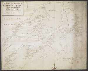
[Map of New England]
![[Map of New England]](https://bpldcassets.blob.core.windows.net/derivatives/images/commonwealth:hx11z5705/image_access_800.jpg)
This map is also available in American Revolutionary Geographies Online (ARGO), a collections portal especially built for material relating to the American Revolutionary War Era. Visit ARGO to learn more about this item and explore the historical geography of North America in the late eighteenth century.
Item Information
- Title:
- [Map of New England]
- Former owner:
- Haldimand, Frederick, Sir, 1718-1791
- Date:
-
1760
- Format:
-
Maps/Atlases
- Location:
- British Library
- Collection (local):
-
British Library Collection
- Subjects:
-
New England--Maps, Manuscript--Early works to 1800
- Places:
-
New England (area)
- Extent:
- 1 map : manuscript pen and ink with watercolour ; 35 x 43 cm
- Terms of Use:
-
No known copyright restrictions.
This work is licensed for use under a Creative Commons Attribution Non-Commercial Share Alike License (CC BY-NC-SA).

- Publisher:
-
[Place of production not identified] :
[producer not identified]
- Scale:
-
Scale not given
- Language:
-
English
- Catalog Record:
-
http://searcharchives.bl.uk/IAMS_VU2:IAMS040-002034118
- Notes:
-
Date range from previous British Library cataloguing and attributed on stylistic grounds (compare published maps referring to the "Seat of War" in New England?), but towards the latter end of this range (1770s) seems probable.
Relief shown pictorially.
With no title, no scale and no information about the cartographer this map shows parts of present-day Massachusetts, Vermont, Connecticut, Rhode Island and New Hampshire.
Shows roads.
Shows three forts at the confluence of the "Ashulot" (Ashuelot) and "Connecticut" rivers - "F. Dummer", "Hindsels F" and "Shanaks Ft".
Previously catalogued with a sketch map showing Fort Detroit (Add Ms 21,686.72.)
Copy at Add Ms 21,686.70-71. Bound in a volume. Manuscript addition of "71" in pencil at upper left, and with "70" to verso. Laid on archival tissue. Paper watermark shows a coat of arms with "CB" beneath. Paper countermark shows "JW".
- Notes (date):
-
9999