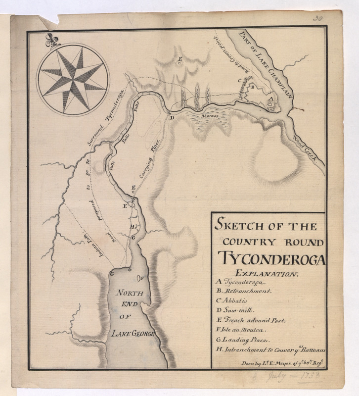
SKETCH OF THE COUNTRY ROUND TYCONDEROGA
This map is also available in American Revolutionary Geographies Online (ARGO), a collections portal especially built for material relating to the American Revolutionary War Era. Visit ARGO to learn more about this item and explore the historical geography of North America in the late eighteenth century.
Item Information
- Title:
- SKETCH OF THE COUNTRY ROUND TYCONDEROGA
- Cartographer:
- Meyer, Elias, -1766
- Former owner:
- Haldimand, Frederick, Sir, 1718-1791
- Name on Item:
-
Doen by L.f. E: Meyer of y:e 60.th Reg.t.
- Date:
-
[1758]
- Format:
-
Maps/Atlases
- Location:
- British Library
- Collection (local):
-
British Library Collection
- Subjects:
-
Fortification--New York (State)--Fort Ticonderoga--Maps, Manuscript--Early works to 1800
Military art and science--New York (State)--Fort Ticonderoga--Maps, Manuscript--Early works to 1800
Fort Ticonderoga (N.Y.)--Maps, Manuscript--Early works to 1800
- Places:
-
Essex (county)Fort Ticonderoga (transport point)
- Extent:
- 1 map : manuscript pen and ink with grey wash ; 20 x 18 cm
- Terms of Use:
-
No known copyright restrictions.
This work is licensed for use under a Creative Commons Attribution Non-Commercial Share Alike License (CC BY-NC-SA).

- Publisher:
-
[Place of production not identified] :
Doen by L.f. E: Meyer of y:e 60.th Reg.t.,
- Scale:
-
Scale not given
- Language:
-
English
- Catalog Record:
-
http://searcharchives.bl.uk/IAMS_VU2:IAMS040-002034118
- Notes:
-
Relief is shown by shading.
Date from previous British Library cataloguing.
Shows title and signature at lower right with a lettered key (A-H) highlighting fortifications ("Retranchmant" and "Intrenchment to couver ye Batteaus") and other buildings of note ("Saw mill").
Shows a decorative compass rose at upper left orienting north to the top of the map.
Shows "Indian path" and "Road proposed to go to surround Tyconderoga". Also shows "Road to crown point".
Names "PART OF LAKE CHAMPLAIN", "NORTH END OF LAKE GEORGE" and "Wood Creek" - shown flowing into Lake Champlain from the south east.
Compare an example held by the William L. Clements Library (Germain Papers. Small Maps 1758 - see Brun 435).
Copy at Add Ms 21,686.30. Bound in a volume. Manuscript addition of "30" in pencil in margin at upper right. Manuscript addition of "8 July 1758" in pencil in margin at lower right. Red stamp of British Museum to verso.
- Notes (date):
-
9999
This date is inferred.

![[Map of Fort Carillon]](https://bpldcassets.blob.core.windows.net/derivatives/images/commonwealth:hx11z179t/image_thumbnail_300.jpg)
![[PLAN de Carillon]](https://bpldcassets.blob.core.windows.net/derivatives/images/commonwealth:hx11z1778/image_thumbnail_300.jpg)