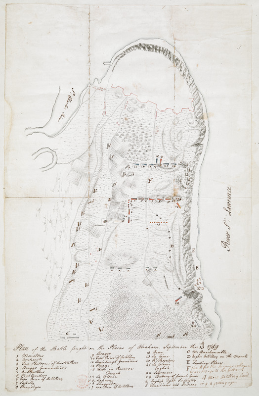
Plan of the Battle fought on the Plains of Abraham, September the 13th 1759
This map is also available in American Revolutionary Geographies Online (ARGO), a collections portal especially built for material relating to the American Revolutionary War Era. Visit ARGO to learn more about this item and explore the historical geography of North America in the late eighteenth century.
Item Information
- Title:
- Plan of the Battle fought on the Plains of Abraham, September the 13th 1759
- Date:
-
[1759]
- Format:
-
Maps/Atlases
- Location:
- British Library
- Collection (local):
-
British Library Collection
- Subjects:
-
Plains of Abraham, Battle of the, Québec, 1759--Maps, Manuscript--Early works to 1800
Military art and science--Québec (Province)--Québec--Maps, Manuscript--Early works to 1800
Québec (Québec)--Maps, Manuscript--Early works to 1800
- Places:
-
CanadaQuébec
- Extent:
- 1 map : manuscript pen and ink with watercolour ; 39 x 25 cm
- Terms of Use:
-
No known copyright restrictions.
This work is licensed for use under a Creative Commons Attribution Non-Commercial Share Alike License (CC BY-NC-SA).

- Publisher:
-
[Place of production not identified] :
[producer not identified]
- Scale:
-
Scale not given
- Language:
-
English
- Catalog Record:
-
http://searcharchives.bl.uk/IAMS_VU2:IAMS032-002087309
- Notes:
-
Relief shown by shading.
Shows title at lower centre with numbered (1-23) and lettered (a-f) key beneath identifying troops and artillery.
Shows descriptive text at centre left and upper centre.
Copy at Add Ms 15,535.3. Small red stamp of British Museum at lower left. Evidence of old folds. Pasted in an album, verso not visible.
- Notes (date):
-
9999
This date is inferred.

![[Map of Quebec and environs showing the position of the English and French troops]](https://bpldcassets.blob.core.windows.net/derivatives/images/commonwealth:hx11xz61s/image_thumbnail_300.jpg)
![[Map of the environs of Quebec showing the position of the English and French troops]](https://bpldcassets.blob.core.windows.net/derivatives/images/commonwealth:hx11xz690/image_thumbnail_300.jpg)


