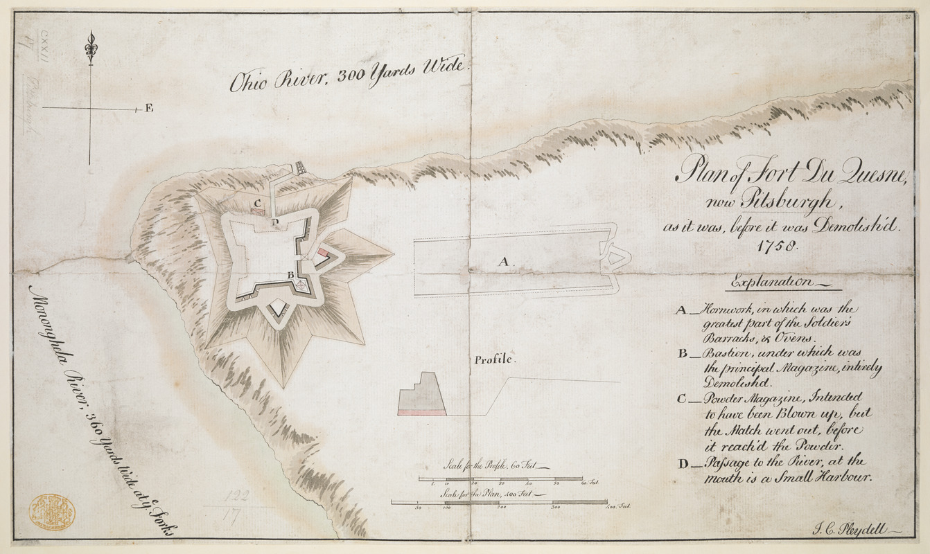
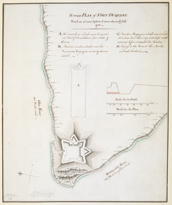
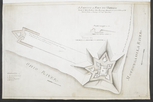
Plan of Fort du Quesne, now Pitsburgh, as it was, before it was Demolish'd
This map is also available in American Revolutionary Geographies Online (ARGO), a collections portal especially built for material relating to the American Revolutionary War Era. Visit ARGO to learn more about this item and explore the historical geography of North America in the late eighteenth century.
Item Information
- Title:
- Plan of Fort du Quesne, now Pitsburgh, as it was, before it was Demolish'd
- Cartographer:
- Pleydell, J. C.
- Former owner:
- George, III, King of Great Britain, 1738-1820
- Donor:
- George, IV, King of Great Britain, 1762-1830
- Name on Item:
-
1758. J.C. Pleydell.
- Date:
-
1758
- Format:
-
Maps/Atlases
Manuscripts
- Location:
- British Library
- Collection (local):
-
British Library Collection
- Subjects:
-
Military art and science--Pennsylvania--Fort Duquesne--Maps, Manuscript--Early works to 1800
Fort Duquesne (Pa.)--Maps, Manuscript--Early works to 1800
United States--History--French and Indian War, 1754-1763--Maps, Manuscript--Early works to 1800
- Places:
-
Allegheny (county)Pittsburgh
- Extent:
- 1 map : manuscript pen and ink with watercolour ; 25 x 42 cm
- Terms of Use:
-
No known copyright restrictions.
This work is licensed for use under a Creative Commons Attribution Non-Commercial Share Alike License (CC BY-NC-SA).

- Scale:
-
Scale approximately 1:1,200
- Language:
-
English
- Catalog Record:
-
http://explore.bl.uk/BLVU1:LSCOP-ALL:BLL01004987646
- Notes:
-
With a "Scale for the Plan, 400 Feet" and a "Scale for the Profile, 60 Feet" at lower centre.
Inset with a sectional profile of the fort wall (scale approximately 1:720).
Shows a lettered key (A-D) identifying locations within the fort at lower right including "C - Powder Magazine, Intended to have been Blown up, but the Match went out, before it reach'd the Powder".
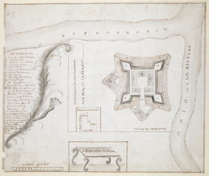
Compare with Maps K.Top.122.18. - a similar map by a different hand.
Titled "A drawn Plan of Fort du Quesne, now Pittsburgh, as it was before it was demolished, 1758, by I.C. Pleydell" in the Catalogue of Maps, Prints, Drawings, etc., forming the geographical and topographical collection attached to the Library of his late Majesty King George the third, etc., London, 1829.
Titled 'A colored "plan of Fort du Quesne (now Pittsburg), as it was before it was demolished, 1758;" drawn by J.C. Pleydell, on a scale of 100 feet to an inch, with profil on a scale of 20 feet to an inch: 1 f. 4 1/2 in. x 9 1/2 in. (Two copies)' in the Catalogue of the manuscript maps, charts, and plans, and of the topographical drawings in the British Museum.
Fort Duquesne in Pittsburgh, Pennsylvania.

![[A colored map of the route between Albany and Oswego; drawn about 1756, on a scale of 2 miles to an inch]](https://bpldcassets.blob.core.windows.net/derivatives/images/commonwealth:hx11z3223/image_thumbnail_300.jpg)
