A Plan of the Plan
This map is also available in American Revolutionary Geographies Online (ARGO), a collections portal especially built for material relating to the American Revolutionary War Era. Visit ARGO to learn more about this item and explore the historical geography of North America in the late eighteenth century.
Item Information
- Title:
- A Plan of the Plan
- Cartographer:
- Thomas, John, the Elder
- Former owner:
- George, III, King of Great Britain, 1738-1820
- Donor:
- George, IV, King of Great Britain, 1762-1830
- Date:
-
1738
- Format:
-
Maps/Atlases
Manuscripts
- Location:
- British Library
- Collection (local):
-
British Library Collection
- Subjects:
-
Military art and science--Georgia--Saint Simons Island--Maps, Manuscript--Early works to 1800
Saint Simons Island (Ga.)--Maps, Manuscript--Early works to 1800
Jekyll Island (Ga.)--Maps, Manuscript--Early works to 1800
- Places:
-
Glynn (county)Saint Simons Island (island)
- Extent:
- 1 map : manuscript pen and ink over pencil ; 15 x 23 cm
- Terms of Use:
-
No known copyright restrictions.
This work is licensed for use under a Creative Commons Attribution Non-Commercial Share Alike License (CC BY-NC-SA).

- Scale:
-
Scale not given
- Language:
-
English
- Catalog Record:
-
http://explore.bl.uk/BLVU1:LSCOP-ALL:BLL01004925108
- Notes:
-
Production details from Cumming (third edition) and from a manuscript note in the British Museum catalogue (Maps C.21 bb.3) referencing a letter from Mrs Margaret Davis Cate, 29 July 1955.
Unfinished pen drawings comprising designs for the engraving of the map with the proposed fortifications. Compare additional drawings - Maps K.Top.122.70.a. / Maps K.Top.122.70.b. / Maps K.Top.122.70.c.
Compare the John Thomas, the Younger, manuscript map at the Fort Frederica National Monument. Digital copy online at http://georgiainfo.galileo.usg.edu/images/uploads/maps/stsimonsmap2.jpg - viewed April 2014 (Cumming, 246A).
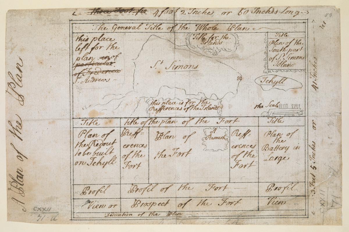
The "plan" for the layout of the engraved map comprises multiple sections including; "The General Title of the Whole Plan", "this place left for the plan of St. Andrews", "Title for the Islands", "Title - Plan of the South part of St Simons Island", "Scale", "This place is for the Refferences of this the Island", "Title of the plan of the Fort", "Plan of the Redout to be built on Jekyll", "Plan of the Fort" "Plan of the Battery in Large", "Profil of the Fort" and "Prospect of the Fort", amongst others.
Titled "A drawn Plan of St. Simon's and Jekyll Islands; with Plans and Profiles of the Battery, the Fort and the Redoubt. Four sheets; unfinished" in the Catalogue of Maps, Prints, Drawings, etc., forming the geographical and topographical collection attached to the Library of his late Majesty King George the third, etc., London, 1829.
Titled "A plan of St. Simon's and Jekyll Islands, shewing the position of the forts, redoubts, &c., unfinished. It is on the same scale and size as the preceding" [on a scale of 1 3/5 inch to a mile: 3 f. x 1 f. 7 in. - see Maps K.Top.122.70.] in the Catalogue of the manuscript maps, charts, and plans, and of the topographical drawings in the British Museum.
Shows Saint Simons Island and Jekyll Island in Georgia.

![[Map of Saint Simons and Jekyll Islands with fortifications]](https://bpldcassets.blob.core.windows.net/derivatives/images/commonwealth:hx11z4564/image_thumbnail_300.jpg)
![[Map of Saint Simons and Jekyll Islands]](https://bpldcassets.blob.core.windows.net/derivatives/images/commonwealth:hx11z454k/image_thumbnail_300.jpg)


