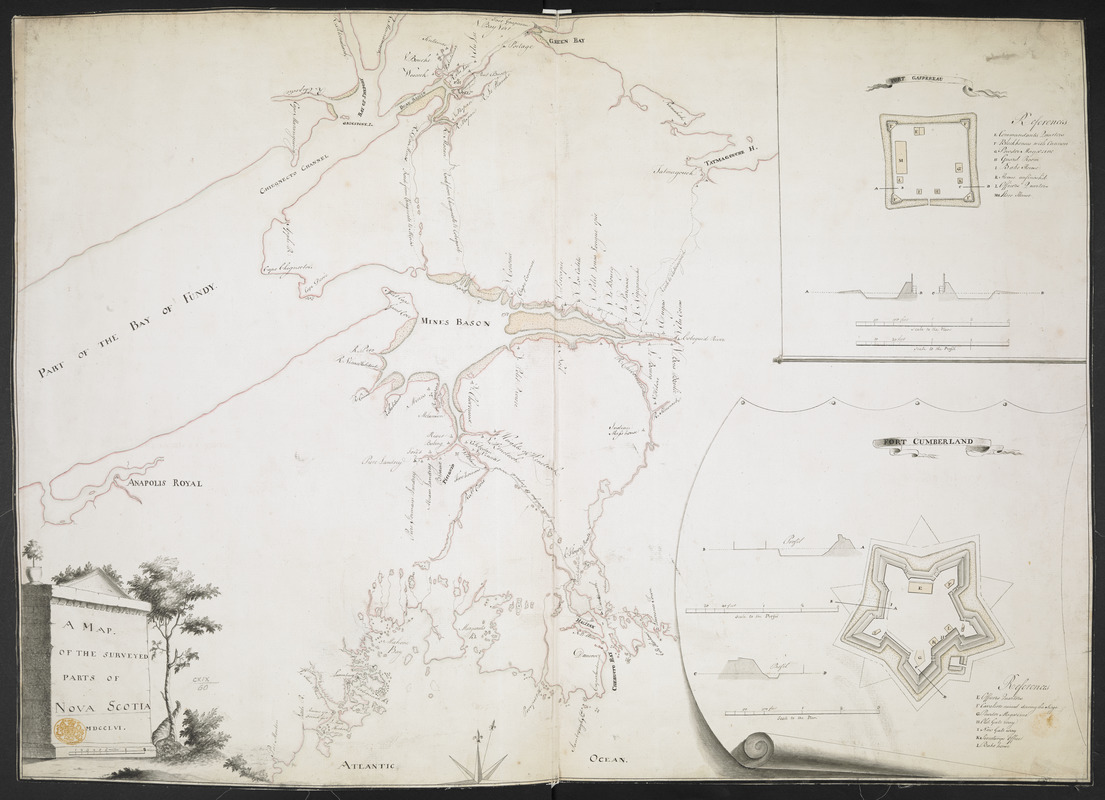
A MAP OF THE SURVEYED PARTS OF NOVA SCOTIA MDCCLVI
This map is also available in American Revolutionary Geographies Online (ARGO), a collections portal especially built for material relating to the American Revolutionary War Era. Visit ARGO to learn more about this item and explore the historical geography of North America in the late eighteenth century.
Item Information
- Title:
- A MAP OF THE SURVEYED PARTS OF NOVA SCOTIA MDCCLVI
- Description:
-
A manuscript map of Nova Scotia (including parts of present-day New Brunswick) produced during the period of the Expulsion of the Acadians (the Great Upheaval) by Engineer John Brewse.
- Former owner:
- George, III, King of Great Britain, 1738-1820
- Donor:
- George, IV, King of Great Britain, 1762-1830
- Cartographer:
- Brewse, John, -1785
- Date:
-
1756
- Format:
-
Maps/Atlases
Manuscripts
- Location:
- British Library
- Collection (local):
-
British Library Collection
- Subjects:
-
Acadians--Nova Scotia--History--Expulsion, 1755--Maps, Manuscript--Early works to 1800
Fort Cumberland (N.B.)--Maps, Manuscript--Early works to 1800
Nova Scotia--Maps, Manuscript--Early works to 1800
- Places:
-
CanadaFort Beauséjour National Historic Park (historical park)
- Extent:
- 1 map : manuscript pen and ink with watercolour ; 51 x 71 cm
- Terms of Use:
-
No known copyright restrictions.
This work is licensed for use under a Creative Commons Attribution Non-Commercial Share Alike License (CC BY-NC-SA).

- Scale:
-
Scale 1:38,160
- Language:
-
English
- Catalog Record:
-
http://explore.bl.uk/BLVU1:LSCOP-ALL:BLL01004987896
- Notes:
-
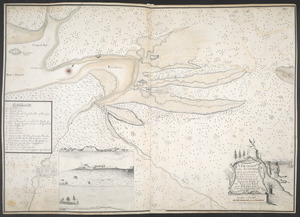
The title and date appear in a decorative cartouche with a classical appearance at lower left, beneath which is the scale given as six miles to one inch.
Consider Engineer John Brewse as cartographer? Stylistic similarities with other maps bearing his name in the King's Topographical Collection (see Maps K.Top.119.68. for a map of Fort Cumberland signed by Brewse).
Cartographic detail focuses on those parts of Nova Scotia important to the British at this time. On the Atlantic coast detail extends from Lunenburg in the east to Lawrence Town in the west, and then northwards to the Bay of Fundy.
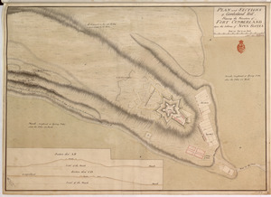
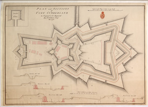
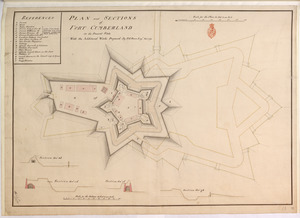
To the right of the map are two inset plans; "FORT GASPEREAU" is mapped at a scale of 100 feet to one inch with a lettered key (E-M) identifying locations of note within the fort. A-D convey the locations of the accompanying cross section, which is mapped at a scale of 20 feet to one inch. Below is "FORT CUMBERLAND" mapped at a scale of 100 feet to one inch with a lettered key (E-L). It too is accompanied by two profile views at the larger scale of 40 feet to one inch.
Dated 1756 (MDCCLVI), this manuscript map has been produced after the Battle of Fort Beauséjour, during Father Le Loutre's War (1751–1755), when the British, under the command of Lt. Col. Robert Monckton, gained control of the fort from the French and changed its name to Fort Cumberland, which is definitively recorded here. However, "FORT GASPEREAU" remains named as such on the map. It was also taken by the British, under Colonel John Winslow, in 1755 and would become known as Fort Monckton before being abandoned later in 1756.
Shows overland routes.
Produced during the period of the Expulsion of the Acadians (the Great Upheaval) by the British.
Titled 'A drawn Map of the Surveyed parts of Nova Scotia, with Plans of Forts Cumberland and Gaspereau, 1756' in the Catalogue of Maps, Prints, Drawings, etc., forming the geographical and topographical collection attached to the Library of his late Majesty King George the third, etc., London, 1829.
Titled 'A colored "Map of the surveyed parts of Nova Scotia, 1756;" drawn on a scale of 6 miles to an inch; with plans of Forts Cumberland and Gaspereau, on a scale of 100 feet to an inch, and sections 20 feet to an inch : 2 f. 3 in. x 1 f. 8 in.' in the Catalogue of the manuscript maps, charts, and plans, and of the topographical drawings in the British Museum.