[A coloured chart of the upper part of Lake Erie at Fort Erie and a detailed plan of Fort Erie, together with three cross sectional drawings]
![[A coloured chart of the upper part of Lake Erie at Fort Erie and a detailed plan of Fort Erie, together with three cross sectional drawings]](https://bpldcassets.blob.core.windows.net/derivatives/images/commonwealth:hx11z482r/image_access_800.jpg)
This map is also available in American Revolutionary Geographies Online (ARGO), a collections portal especially built for material relating to the American Revolutionary War Era. Visit ARGO to learn more about this item and explore the historical geography of North America in the late eighteenth century.
Item Information
- Title:
- [A coloured chart of the upper part of Lake Erie at Fort Erie and a detailed plan of Fort Erie, together with three cross sectional drawings]
- Description:
-
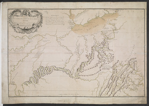
A manuscript map of Lake Erie within its wider geographical setting together with a detailed plan of the fort itself and three cross sectional drawings. Built under the direction of John Montresor and drawn by Francis Pfister in 1764.
- Cartographer:
- Pfister, Francis, 1740-1777
- Former owner:
- George, III, King of Great Britain, 1738-1820
- Donor:
- George, IV, King of Great Britain, 1762-1830
- Contributor:
- Montrésor, John, 1736-1799
- Date:
-
1764
- Format:
-
Maps/Atlases
Manuscripts
- Location:
- British Library
- Collection (local):
-
British Library Collection
- Subjects:
-
Military maps--Early works to 1800
Fortification--Erie, Lake--Maps, Manuscript--Early works to 1800
Fort Erie (Ont.)--Maps, Manuscript--Early works to 1800
Erie, Lake--Maps, Manuscript--Early works to 1800
Erie, Lake--Defences--Early works to 1800
- Places:
-
Erie, Lake
- Extent:
- 2 maps and 3 building cross sections on 1 sheet : manuscript pen and ink with watercolour ; sheet 28 x 46 cm
- Terms of Use:
-
No known copyright restrictions.
This work is licensed for use under a Creative Commons Attribution Non-Commercial Share Alike License (CC BY-NC-SA).

- Scale:
-
Scales differ
- Language:
-
English
- Catalog Record:
-
http://explore.bl.uk/BLVU1:LSCOP-ALL:BLL01004987721
- Notes:
-
Relief shown pictorially.
Composite sheet comprising 5 separate elements, each with its own scale. The larger map to the right of the sheet shows Fort Erie's situation at the upper end of Lake Erie, drawn at a scale of 900 yards to one inch (1:22,000), with Buffalo Creek named on the opposing side. The left side of the sheet comprises a detailed plan of Fort Erie at the scale of 70 feet to one inch (1:840). In the centre of the sheet are three cross sectional drawings of the fort at the scale of 15 feet to one inch (1:180).
A manuscript note at lower left reads "Built under the direction of John Montresor Engineer 1764".
Titled 'A colored chart of the upper part of Lake Erie ; on a scale of 900 yards to an inch : with a "plan of Fort Erie, built under the direction of John Montresor, engineer, 1764;" on a scale of 200 feet to an inch ; the sections on a scale of 15 feet to an inch ; drawn by Francis Pfister, 1764 : 1 f. 6 in. x 11 in.' in the 'Catalogue of the manuscript maps, charts, and plans, and of the topographical drawings in the British Museum'.
Titled "A drawn Plan of Fort Erie, built under the directions of John Montresor, Engr. 1764 ; drawn by F.Pfister, 1764" in the Catalogue of Maps, Prints, Drawings, etc, forming the geographical and topographical collection attached to the Library of his late Majesty King George the third etc., London, 1829.

![[Map of Fort Detroit and environs]](https://bpldcassets.blob.core.windows.net/derivatives/images/commonwealth:hx11xz63b/image_thumbnail_300.jpg)
![[A map of Lake Erie with the route southward from Fort Presqu'Isle to Fort Cumberland, with inset plans of Fort Pitt, Fort Venango, Fort Le Boeuf and Fort Presque Isle]](https://bpldcassets.blob.core.windows.net/derivatives/images/commonwealth:6108vw18h/image_thumbnail_300.jpg)
![[An outline plan of the harbour and fortifications of Louisbourg]](https://bpldcassets.blob.core.windows.net/derivatives/images/commonwealth:hx11z5128/image_thumbnail_300.jpg)
