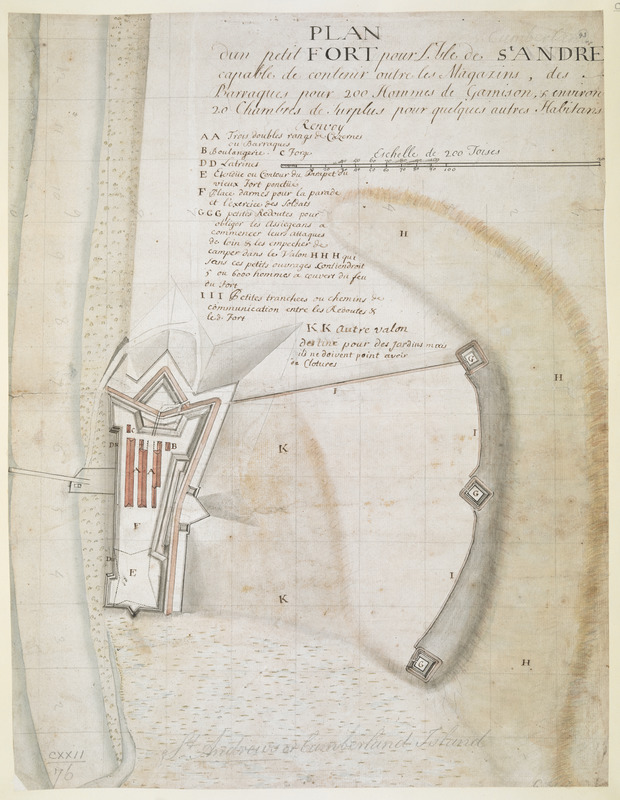
PLAN dun petit FORT pour l'Isle de S.t ANDRE capable de contenir outre les Magazins, des Barraques pour 200 Hommes de Garrison, & environ 20 Chambres de Surplus pour queleques autres Habitans
This map is also available in American Revolutionary Geographies Online (ARGO), a collections portal especially built for material relating to the American Revolutionary War Era. Visit ARGO to learn more about this item and explore the historical geography of North America in the late eighteenth century.
Item Information
- Title:
- PLAN dun petit FORT pour l'Isle de S.t ANDRE capable de contenir outre les Magazins, des Barraques pour 200 Hommes de Garrison, & environ 20 Chambres de Surplus pour queleques autres Habitans
- Cartographer:
- Thomas, John, the Elder
- Former owner:
- George, III, King of Great Britain, 1738-1820
- Donor:
- George, IV, King of Great Britain, 1762-1830
- Date:
-
1738
- Format:
-
Maps/Atlases
Manuscripts
- Location:
- British Library
- Collection (local):
-
British Library Collection
- Subjects:
-
Military art and science--Georgia--Cumberland Island--Maps, Manuscript--Early works to 1800
Fortification--Georgia--Cumberland Island--Maps, Manuscript--Early works to 1800
Cumberland Island (Ga.)--Maps, Manuscript--Early works to 1800
Fort Saint Andrew (Ga.)--Maps, Manuscript--Early works to 1800
- Places:
-
Camden (county)Cumberland Island (island)
- Extent:
- 1 map : manuscript pen and ink with watercolour over pencil ; 40 x 30 cm
- Terms of Use:
-
No known copyright restrictions.
This work is licensed for use under a Creative Commons Attribution Non-Commercial Share Alike License (CC BY-NC-SA).

- Scale:
-
Scale approximately 1:3,200
- Language:
-
French
- Catalog Record:
-
http://explore.bl.uk/BLVU1:LSCOP-ALL:BLL01004923237
- Notes:
-
Production details from Cumming (third edition) and from a manuscript note in the British Museum catalogue (Maps C.21 bb.3) referencing a letter from Mrs Margaret Davis Cate, 29 July 1955.
Relief (marsh areas) shown pictorially.
Scale at upper right "Echelle de 200 Toises".
Title at upper right.
A note in pencil above the title adds "Cumberland" in place of "ANDRE" - the title should read "PLAN dun petit FORT pour l'Isle de CUMBERLAND ...".
Lettered key (A-K) beneath the title identifying locations of note.
Shows a numbered grid system in pencil.
Titled "Plan dessiné d'un petit Fort pour l'Isle de St. Andre" in the Catalogue of Maps, Prints, Drawings, etc., forming the geographical and topographical collection attached to the Library of his late Majesty King George the third, etc., London, 1829.
Titled "Plan d'un petit Fort pour l'Isle de St André" or Cumberland Island; drawn on a scale of 33 toises to an inch: 1 f. 3 in. x 1 f. in the Catalogue of the manuscript maps, charts, and plans, and of the topographical drawings in the British Museum.
A proposed plan for Fort Saint Andrews on Cumberland Island, Georgia.


