[Map of the proposed fort and adjacent redoubt on Saint Simons Island]
![[Map of the proposed fort and adjacent redoubt on Saint Simons Island]](https://bpldcassets.blob.core.windows.net/derivatives/images/commonwealth:hx11z468x/image_access_800.jpg)
This map is also available in American Revolutionary Geographies Online (ARGO), a collections portal especially built for material relating to the American Revolutionary War Era. Visit ARGO to learn more about this item and explore the historical geography of North America in the late eighteenth century.
Item Information
- Title:
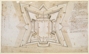
- [Map of the proposed fort and adjacent redoubt on Saint Simons Island]
- Cartographer:
- Thomas, John, the Elder
- Former owner:
- George, III, King of Great Britain, 1738-1820
- Donor:
- George, IV, King of Great Britain, 1762-1830
- Date:
-
1738
- Format:
-
Maps/Atlases
Manuscripts
- Location:
- British Library
- Collection (local):
-
British Library Collection
- Subjects:
-
Military art and science--Georgia--Saint Simons Island--Maps, Manuscript--Early works to 1800
Fortification--Georgia--Saint Simons Island--Maps, Manuscript--Early works to 1800
Saint Simons Island (Ga.)--Maps, Manuscript--Early works to 1800
- Places:
-
Glynn (county)Saint Simons Island (island)
- Extent:
- 1 map : manuscript pen and ink with watercolour over pencil ; 27 x 57 cm
- Terms of Use:
-
No known copyright restrictions.
This work is licensed for use under a Creative Commons Attribution Non-Commercial Share Alike License (CC BY-NC-SA).

- Scale:
-
Scale approximately 1:1,750
- Language:
-
French
- Catalog Record:
-
http://explore.bl.uk/BLVU1:LSCOP-ALL:BLL01004987603
- Notes:
-
Production details from a manuscript note in the British Museum catalogue (Maps C.21 bb.3) referencing a letter from Mrs Margaret Davis Cate, 29 July 1955.
Cumming (third edition) does not attribute the map to John Thomas and dates the map about 1760, but also suggests this may be incorrect.
Relief (marsh areas) shown pictorially.
Compare Maps K.Top.122.74. - similar external fortfications but arrangement of buildings within this plan of the the fort differ.
With the scale "Echelle de 200 Toises" across the bottom of the map.
With a simple compass rose at lower right orienting north to the top of the map.
With a detailed explanation and partial lettered key at upper right and further explanatory text across the bottom of the map.
The map lacks a border on the upper edge and the explanatory text at uper right begins midway (?) through a sentence - incomplete.
Titled "Plan dessiné d'un Fort dans l'Isle de St. Simon" in the Catalogue of Maps, Prints, Drawings, etc., forming the geographical and topographical collection attached to the Library of his late Majesty King George the third, etc., London, 1829.
Titled "A colored plan of the fort in St. Simon's Island and of the adjacent redoubt; drawn by Capt. John Thomas in 1738 on a scale of 22 toises to an inch; 1 f. 10 in. x 10 1/2 in." in the Catalogue of the manuscript maps, charts, and plans, and of the topographical drawings in the British Museum.