[Map of Saint Simons and Jekyll Islands]
![[Map of Saint Simons and Jekyll Islands]](https://bpldcassets.blob.core.windows.net/derivatives/images/commonwealth:hx11z454k/image_access_800.jpg)
This map is also available in American Revolutionary Geographies Online (ARGO), a collections portal especially built for material relating to the American Revolutionary War Era. Visit ARGO to learn more about this item and explore the historical geography of North America in the late eighteenth century.
Item Information
- Title:
- [Map of Saint Simons and Jekyll Islands]
- Cartographer:
- Auspourger, Samuel
- Former owner:
- George, III, King of Great Britain, 1738-1820
- Donor:
- George, IV, King of Great Britain, 1762-1830
- Name on Item:
-
[Samuel Auspourger].
- Date:
-
1739
- Format:
-
Maps/Atlases
Manuscripts
- Location:
- British Library
- Collection (local):
-
British Library Collection
- Subjects:
-
Saint Simons Island (Ga.)--Maps, Manuscript--Early works to 1800
Jekyll Island (Ga.)--Maps, Manuscript--Early works to 1800
Fort Frederica (Ga.)--Maps, Manuscript--Early works to 1800
- Places:
-
Glynn (county)Saint Simons Island (island)Fort Frederica National Monument (park)
- Extent:
- 1 map on 3 sheets : manuscript pen and ink over pencil ; 111 x 50 cm
- Terms of Use:
-
No known copyright restrictions.
This work is licensed for use under a Creative Commons Attribution Non-Commercial Share Alike License (CC BY-NC-SA).

- Scale:
-
Scale approximately 1:40,550
- Language:
-
English
- Catalog Record:
-
http://explore.bl.uk/BLVU1:LSCOP-ALL:BLL01004925106
- Notes:
-
Production details from Cumming (third edition - previous editions incorrect).
Spelling of Auspourger from Cadle [Auspouger in Cumming / Augspourger in manuscript note in British Museum catalogue - Maps C.21 bb.3 - referencing a letter from Mrs Margaret Davis Cate, 29 July 1955].
Relief shown pictorially - marsh and forest areas are delineated.
Shows "A Scale of 2 Milles or 10000 fet".
Shows a numbered grid system.
With a decorative compass rose at centre left orienting north to the left of the page.
Faint manuscript annotations in pencil.
Ink border to sheet showing St Simons. Ink border lacking on map of Jekyll Island - unfinished?
Shows forts (Fort King George to the north and Delegal's Fort to the south?).
Titled "A drawn Plan of St. Simon's and Jekyll Islands on the Coast of Georgia: two sheets" in the Catalogue of Maps, Prints, Drawings, etc., forming the geographical and topographical collection attached to the Library of his late Majesty King George the third, etc., London, 1829.
Titled "A map of St. Simon's and Jekyll Islands on the coast of Georgia: drawn about 1760, on a scale of 1 3/5 inch to a mile: 3 f. x 1 f. 7 in." in the Catalogue of the manuscript maps, charts, and plans, and of the topographical drawings in the British Museum.

![[Map of Saint Simons and Jekyll Islands with fortifications]](https://bpldcassets.blob.core.windows.net/derivatives/images/commonwealth:hx11z4564/image_thumbnail_300.jpg)
![[A sketch map of the proposed battery (?) on Jekyll Island (?)]](https://bpldcassets.blob.core.windows.net/derivatives/images/commonwealth:hx11z460q/image_thumbnail_300.jpg)
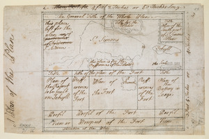
![[Map and profiles of proposed (?) fortifications on Jekyll Island (?)]](https://bpldcassets.blob.core.windows.net/derivatives/images/commonwealth:hx11z458p/image_thumbnail_300.jpg)
