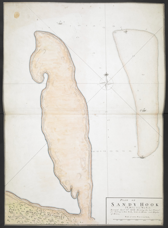
PLAN OF SANDY HOOK 28. Miles from New York
This map is also available in American Revolutionary Geographies Online (ARGO), a collections portal especially built for material relating to the American Revolutionary War Era. Visit ARGO to learn more about this item and explore the historical geography of North America in the late eighteenth century.
Item Information
- Title:
- PLAN OF SANDY HOOK 28. Miles from New York
- Former owner:
- George, III, King of Great Britain, 1738-1820
- Donor:
- George, IV, King of Great Britain, 1762-1830
- Name on Item:
-
Surveyed April 15.th 1757. Shewing the best Channel for Sailing to New York, with it's Banks and Depths of Water.
- Date:
-
1757
- Format:
-
Maps/Atlases
Manuscripts
- Location:
- British Library
- Collection (local):
-
British Library Collection
- Subjects:
-
Sandy Hook (N.J.)--Maps--Early works to 1800
- Places:
-
Monmouth (county)Sandy Hook (cape)
- Extent:
- 1 map : manuscript pen and ink with watercolour ; 72 x 52 cm
- Terms of Use:
-
No known copyright restrictions.
This work is licensed for use under a Creative Commons Attribution Non-Commercial Share Alike License (CC BY-NC-SA).

- Scale:
-
Scale approximatley 1:12,000
- Language:
-
English
- Catalog Record:
-
http://explore.bl.uk/BLVU1:LSCOP-ALL:BLL01004987668
- Notes:
-
Shows sounding depths.
Relief shown pictorially.
Title at lower right with a "Scale of 1000. Feet to an Inch".
Illustrated with a decorative compass rose and four sailing vessels.
Titled "A drawn Plan of Sandy Hook, twenty-eight Miles from New York, surveyed April 15th, 1757" in the Catalogue of Maps, Prints, Drawings, etc., forming the geographical and topographical collection attached to the Library of his late Majesty King George the third, etc., London, 1829.
Titled 'A "plan of Sandy Hook, 28 miles from New York, surveyed April 15th, 1757: shewing the best channel for sailing to New York, with its banks and depths of water;" drawn on a scale of 1000 feet to an inch: 2 f. 4 in. x 1 f. 8 in.' in the Catalogue of the manuscript maps, charts, and plans, and of the topographical drawings in the British Museum.


