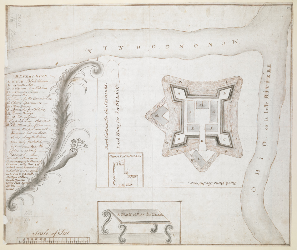
A PLAN of FORT De Quesne
This map is also available in American Revolutionary Geographies Online (ARGO), a collections portal especially built for material relating to the American Revolutionary War Era. Visit ARGO to learn more about this item and explore the historical geography of North America in the late eighteenth century.
Item Information
- Title:
- A PLAN of FORT De Quesne
- Former owner:
- George, III, King of Great Britain, 1738-1820
- Donor:
- George, IV, King of Great Britain, 1762-1830
- Date:
-
1754–1758
- Format:
-
Maps/Atlases
Manuscripts
- Location:
- British Library
- Collection (local):
-
British Library Collection
- Subjects:
-
Military art and science--Pennsylvania--Fort Duquesne--Maps, Manuscript--Early works to 1800
Fort Duquesne (Pa.)--Maps, Manuscript--Early works to 1800
United States--History--French and Indian War, 1754-1763--Maps, Manuscript--Early works to 1800
- Places:
-
Allegheny (county)Pittsburgh
- Extent:
- 1 map : manuscript pen and ink with watercolour ; 30 x 36 cm
- Terms of Use:
-
No known copyright restrictions.
This work is licensed for use under a Creative Commons Attribution Non-Commercial Share Alike License (CC BY-NC-SA).

- Scale:
-
Scale approximately 1:600
- Language:
-
English
- Catalog Record:
-
http://explore.bl.uk/BLVU1:LSCOP-ALL:BLL01004987645
- Notes:
-
Date from reference to fort not being finished on the map - Fort Duquesne was built by the French in 1754 (before being demolished in 1758).
"Scale of feet" at lower left.
Title at lower centre drawn on a decorative table.
With a list of references (A-N) and brief text at centre left separated from the map by a foliate surround.
Inset witha "PROFILE of the WALL".
Titled "A drawn Plan of Fort du Quesne" in the Catalogue of Maps, Prints, Drawings, etc., forming the geographical and topographical collection attached to the Library of his late Majesty King George the third, etc., London, 1829.
Titled "A plan of Fort de Quesne" (now Pittsburgh), at the junction of the Ohio and the Monongahela; drawn before the fort was quite finished, on a scale of 40 feet to an inch: 1 f. 2 in. x 11 1/2 in." in the Catalogue of the manuscript maps, charts, and plans, and of the topographical drawings in the British Museum.
Fort Duquesne in Pittsburgh, Pennsylvania.

![[A colored map of the route between Albany and Oswego; drawn about 1756, on a scale of 2 miles to an inch]](https://bpldcassets.blob.core.windows.net/derivatives/images/commonwealth:hx11z3223/image_thumbnail_300.jpg)
