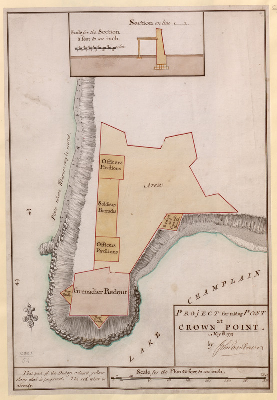
PROJECT for taking POST at CROWN POINT
This map is also available in American Revolutionary Geographies Online (ARGO), a collections portal especially built for material relating to the American Revolutionary War Era. Visit ARGO to learn more about this item and explore the historical geography of North America in the late eighteenth century.
Item Information
- Title:
- PROJECT for taking POST at CROWN POINT
- Cartographer:
- Montrésor, John, 1736-1799
- Former owner:
- George, III, King of Great Britain, 1738-1820
- Donor:
- George, IV, King of Great Britain, 1762-1830
- Name on Item:
-
May 13.th 1774 by John Montresor.
- Date:
-
1774
- Format:
-
Maps/Atlases
Manuscripts
- Location:
- British Library
- Collection (local):
-
British Library Collection
- Subjects:
-
Fortification--New York (State)--Crown Point--Maps, Manuscript--Early works to 1800
Military art and science--New York (State)--Crown Point--Maps, Manuscript--Early works to 1800
Crown Point (N.Y.)--Maps, Manuscript--Early works to 1800
United States--History--French and Indian War, 1754-1763--Maps, Manuscript--Early works to 1800
- Places:
-
Essex (county)Crown Point (cape)
- Extent:
- 1 map : manuscript pen and ink with watercolour ; 50 x 34 cm
- Terms of Use:
-
No known copyright restrictions.
This work is licensed for use under a Creative Commons Attribution Non-Commercial Share Alike License (CC BY-NC-SA).

- Scale:
-
Scale 1:480
- Language:
-
English
- Catalog Record:
-
http://explore.bl.uk/BLVU1:LSCOP-ALL:BLL01004987788
- Notes:
-
Relief is shown by shading.
With a "Scale for the Plan 40 feet to an inch" at lower right.
A textual note at lower left reads "That part of the Design colour'd yellow shews what is proposed. The red what is already."
The new proposals include officers' pavillions, soldiers barracks and two instances of a "Bog House".
With an inset cross section at the top of the map at a scale of 8 feet to an inch (1:96).
The William L. Clements Library at the University of Michigan hold another copy of this map (Map Division M-1298. Maps 4-L-22.). It is also dated May 13th 1774 and signed by John Montresor. However, the name "Wm. Brasier Dealit." is also given at lower right.
The National Archives also hold a copy of the map. "1 item (enclosure to General Haldimand's letter of 1 June 1774) extracted from CO 5/91 (f 317). New York. 'Project for taking Post at Crown Point 13th. May 1774 by John Montresor Commdg. Engr. at N. York. Copy. W. Brasier Delt. 29th May 1774': plan and section of a fort showing work done and proposed. Scales: 1 inch to 40 feet (plan); 1 inch to 8 feet (section). Compass indicator" with the reference MPG 1/355.
A “Project for taking Post at Crown Point, 13th May 1774” is also held by the William L. Clements Library at the University of Michigan (Map Division M-1298. Maps 4-L-22.) and is featured in their online exhibition "The Geometry of War: Fortification Plans from 18th-century America" at http://www.clements.umich.edu/exhibits/online/geometry_of_war/geoamberina.php (viewed 2014).
Titled "A drawn Project for taking Post at Crown Point, May 13th, 1774: by I. Montresor" in the Catalogue of Maps, Prints, Drawings, etc., forming the geographical and topographical collection attached to the Library of his late Majesty King George the third, etc., London, 1829.
Titled 'A colored "project for taking post at [the Grenadier redoubt near] Crown Point, May 13th, 1774: by John Montresor;" drawn on a scale of 40 feet to an inch, with section on a scale of 8 feet to an inch: 1 f. 8 in. x 1 f. 1 in.' in the Catalogue of the manuscript maps, charts, and plans, and of the topographical drawings in the British Museum.